
Topografische Karte Naga
Interaktive Karte
Klicken Sie auf die Karte, um die Höhe anzuzeigen.
Über diese Karte
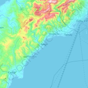
Name: Topografische Karte Naga, Höhe, Relief.
Ort: Naga, Cebu, Central Visayas, 6037, Philippines (10.04847 123.59910 10.36847 123.91910)
Durchschnittliche Höhe: 102 m
Minimale Höhe: -1 m
Maximale Höhe: 751 m
Andere topografische Karten
Klicken Sie auf eine Karte, um ihre Topografie, ihre Höhe und ihr Relief anzuzeigen.
Banilad Town Center
Philippines > Cebu > Banilad > Banilad Town Center
Banilad Town Center, Banilad, Cebu, Central Visayas, 6666, Philippines
Durchschnittliche Höhe: 51 m
Alcoy
Philippines > Cebu > Alcoy
Alcoy, Cebu, Central Visayas, 6023, Philippines
Durchschnittliche Höhe: 136 m
Inganio
Philippines > Cebu > Inganio
Inganio, Cebu, Central Visayas, 6015, Philippines
Durchschnittliche Höhe: 3 m