
Topografische Karte Bishop's Stortford
Interaktive Karte
Klicken Sie auf die Karte, um die Höhe anzuzeigen.
Über diese Karte
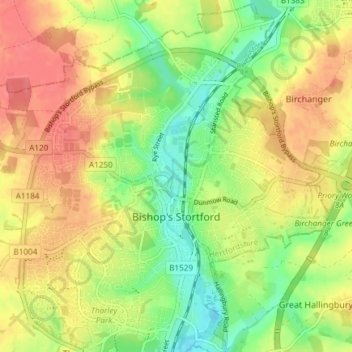
Name: Topografische Karte Bishop's Stortford, Höhe, Relief.
Durchschnittliche Höhe: 83 m
Minimale Höhe: 52 m
Maximale Höhe: 111 m
Stortford, along with the rest of Britain, has a temperate maritime climate, with cool summers and mild winters. The nearest weather station for which averages and extremes are available is Stansted Airport, about 2+1⁄2 miles (4 kilometres) due east of Stortford's town centre. Located at an elevation of over 100 m, the weather station, and parts of Stortford in general are marginally cooler throughout the year than the Cambridgeshire area to the north or the London area to the south. Nonetheless, Stortford is still warmer than the English average.
Andere topografische Karten
Klicken Sie auf eine Karte, um ihre Topografie, ihre Höhe und ihr Relief anzuzeigen.
Hertford Heath
United Kingdom > England > Hertfordshire > East Hertfordshire
Hertford Heath, East Hertfordshire, Hertfordshire, England, United Kingdom
Durchschnittliche Höhe: 74 m
Ware
United Kingdom > England > Hertfordshire > East Hertfordshire
Ware, East Hertfordshire, Hertfordshire, England, United Kingdom
Durchschnittliche Höhe: 55 m
Stanstead Abbotts
United Kingdom > England > Hertfordshire > East Hertfordshire
Stanstead Abbotts, East Hertfordshire, Hertfordshire, England, SG12 8HU, United Kingdom
Durchschnittliche Höhe: 48 m