
Topografische Karte Branch
Interaktive Karte
Klicken Sie auf die Karte, um die Höhe anzuzeigen.
Über diese Karte
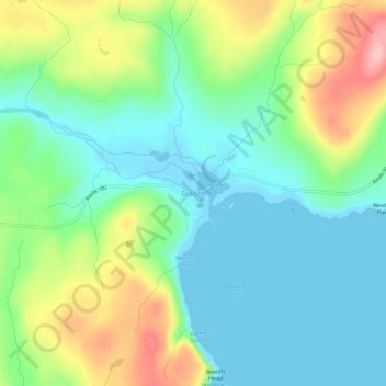
Name: Topografische Karte Branch, Höhe, Relief.
Ort: Branch, Newfoundland, Newfoundland and Labrador, Canada (46.86249 -53.97332 46.90249 -53.93332)
Durchschnittliche Höhe: 53 m
Minimale Höhe: -2 m
Maximale Höhe: 167 m
Andere topografische Karten
Klicken Sie auf eine Karte, um ihre Topografie, ihre Höhe und ihr Relief anzuzeigen.
James Island
Canada > Newfoundland and Labrador
James Island, Newfoundland, Newfoundland and Labrador, Canada
Durchschnittliche Höhe: 2 m
Clarke's Beach
Canada > Newfoundland and Labrador
Clarke's Beach, Newfoundland, Newfoundland and Labrador, Canada
Durchschnittliche Höhe: 54 m
Otterbury
Canada > Newfoundland and Labrador
Otterbury, Newfoundland, Newfoundland and Labrador, Canada
Durchschnittliche Höhe: 31 m
Cottrell's Cove
Canada > Newfoundland and Labrador
Cottrell's Cove, Newfoundland, Newfoundland and Labrador, Canada
Durchschnittliche Höhe: 35 m
Bonavista Bay
Canada > Newfoundland and Labrador
Bonavista Bay, Newfoundland, Newfoundland and Labrador, Canada
Durchschnittliche Höhe: 17 m
Admirals Beach
Canada > Newfoundland and Labrador
Admirals Beach, Newfoundland, Newfoundland and Labrador, Canada
Durchschnittliche Höhe: 24 m
Southern Arm
Canada > Newfoundland and Labrador > Main Brook
Southern Arm, Main Brook, Newfoundland, Newfoundland and Labrador, Canada
Durchschnittliche Höhe: 2 m
Goat Island
Canada > Newfoundland and Labrador > Little Bay Islands
Goat Island, Little Bay Islands, Newfoundland, Newfoundland and Labrador, Canada
Durchschnittliche Höhe: 8 m
Cottrells Cove
Canada > Newfoundland and Labrador > Cottrell's Cove
Cottrells Cove, Cottrell's Cove, Newfoundland, Newfoundland and Labrador, Canada
Durchschnittliche Höhe: 30 m
Horn Head
Canada > Newfoundland and Labrador > Renews-Cappahayden
Horn Head, Renews-Cappahayden, Newfoundland, Newfoundland and Labrador, Canada
Durchschnittliche Höhe: 12 m
Pig Island
Canada > Newfoundland and Labrador > Margaree
Pig Island, Margaree, Newfoundland, Newfoundland and Labrador, Canada
Durchschnittliche Höhe: 6 m
Labrador
Canada > Newfoundland and Labrador
Labrador, Newfoundland and Labrador, Canada
Durchschnittliche Höhe: 238 m
Ireland's Eye
Canada > Newfoundland and Labrador
Ireland's Eye, Newfoundland, Newfoundland and Labrador, Canada
Durchschnittliche Höhe: 9 m
Wigmore
Canada > Newfoundland and Labrador > St. John's
Wigmore, St. John's, Newfoundland, Newfoundland and Labrador, Canada
Durchschnittliche Höhe: 118 m
Steady Brook
Canada > Newfoundland and Labrador > Steady Brook
Steady Brook, Newfoundland and Labrador, A2H 2N2, Canada
Durchschnittliche Höhe: 145 m
Long Range Mountains
Canada > Newfoundland and Labrador
Long Range Mountains, Newfoundland and Labrador, Canada
Durchschnittliche Höhe: 557 m