
Spenden
Rüste dich für dein nächstes Abenteuer:
Als Amazon-Partner verdient diese Website an qualifizierten Käufen, ohne zusätzliche Kosten für Sie.
Topografische Karte Diamond Springs
Klicken Sie auf die Karte, um die Höhe anzuzeigen.
Spenden
Rüste dich für dein nächstes Abenteuer:
Als Amazon-Partner verdient diese Website an qualifizierten Käufen, ohne zusätzliche Kosten für Sie.
Diamond Springs
Diamond Springs (formerly, Diamond Spring and Diamond) is a census-designated place (CDP) in El Dorado County, California, United States. It is part of the Sacramento–Arden-Arcade–Roseville Metropolitan Statistical Area. The population was 11,037 at the 2010 census, up from 4,888 at the 2000 census. The town is registered as California Historical Landmark number 487. It lies at an elevation of 1791 feet (546 m).
Spenden
Rüste dich für dein nächstes Abenteuer:
Als Amazon-Partner verdient diese Website an qualifizierten Käufen, ohne zusätzliche Kosten für Sie.
Über diese Karte
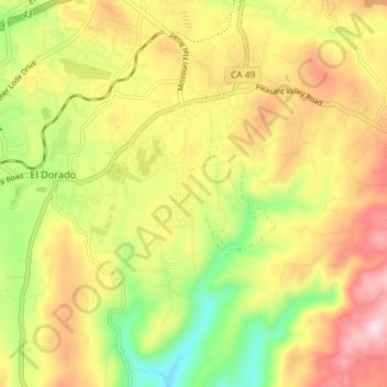
Name: Topografische Karte Diamond Springs, Höhe, Relief.
Durchschnittliche Höhe: 531 m
Minimale Höhe: 349 m
Maximale Höhe: 711 m
Spenden
Rüste dich für dein nächstes Abenteuer:
Als Amazon-Partner verdient diese Website an qualifizierten Käufen, ohne zusätzliche Kosten für Sie.
Andere topografische Karten
Klicken Sie auf eine Karte, um ihre Topografie, ihre Höhe und ihr Relief anzuzeigen.
Pollock Pines
United States > California > El Dorado County
Pollock Pines is a census-designated place (CDP) in El Dorado County, California, United States. It is part of the Sacramento–Arden-Arcade–Roseville Metropolitan Statistical Area. Pollock Pines lies at an elevation of 3,980 feet (1,210 m) in the Sierra Nevada. The population was 6,871 at the 2010 census,…
Durchschnittliche Höhe: 1.122 m
Spenden
Rüste dich für dein nächstes Abenteuer:
Als Amazon-Partner verdient diese Website an qualifizierten Käufen, ohne zusätzliche Kosten für Sie.
Diamond Springs
United States > California > El Dorado County
Diamond Springs (formerly, Diamond Spring and Diamond) is a census-designated place (CDP) in El Dorado County, California, United States. It is part of the Sacramento–Arden-Arcade–Roseville Metropolitan Statistical Area. The population was 11,037 at the 2010 census, up from 4,888 at the 2000 census. The…
Durchschnittliche Höhe: 531 m
Spenden
Rüste dich für dein nächstes Abenteuer:
Als Amazon-Partner verdient diese Website an qualifizierten Käufen, ohne zusätzliche Kosten für Sie.
El Dorado
United States > California > El Dorado County
El Dorado (Spanish for "The Golden") is an unincorporated community in El Dorado County, California. It is located 4 miles (6.4 km) southwest of Placerville, at an elevation of 1608 feet (490 m). The population was 4,096 at the 2000 census. The town is registered as California Historical Landmark #486. The ZIP…
Durchschnittliche Höhe: 511 m
Cameron Park
United States > California > El Dorado County
Cameron Park is situated in an interior chaparral zone or brush zone just east of the Central Valley. It is the closest population center to the Pine Hill Ecological Reserve. Native vegetation includes an abundance of redbud and manzanita bushes, and brush in general. Where treed the native trees are primarily…
Durchschnittliche Höhe: 390 m
Lake Tahoe Basin Management Unit
United States > California > El Dorado County
The Lake Tahoe Basin Management Unit is a United States National Forest that manages and protects public land surrounding Lake Tahoe and the Lake Tahoe Basin. Straddling the state borders of California and Nevada in the Sierra Nevada, the LTBMU encompasses 154,851 acres (626 km²) of National Forest system…
Durchschnittliche Höhe: 1.981 m
Spenden
Rüste dich für dein nächstes Abenteuer:
Als Amazon-Partner verdient diese Website an qualifizierten Käufen, ohne zusätzliche Kosten für Sie.
Eldorado National Forest
United States > California > El Dorado County
The forest ranges in elevation from 1,000 feet (300 m) in the foothills to more than 10,000 feet (3,000 m) above sea level along the Sierra crest. The mountainous topography is broken by the steep canyons of the Mokelumne, Cosumnes, American, and Rubicon rivers. Plateaus of generally moderate relief are…
Durchschnittliche Höhe: 1.807 m
South Lake Tahoe
United States > California > El Dorado County > South Lake Tahoe > South Lake Tahoe
Durchschnittliche Höhe: 1.944 m
Spenden
Rüste dich für dein nächstes Abenteuer:
Als Amazon-Partner verdient diese Website an qualifizierten Käufen, ohne zusätzliche Kosten für Sie.
Bridlewood Canyon
United States > California > El Dorado County > Cameron Park
Durchschnittliche Höhe: 376 m
Kingsville
United States > California > El Dorado County
Kingsville (formerly, Kingville) is an unincorporated community in El Dorado County, California. It is located 5 miles (8 km) southwest of Placerville, at an elevation of 1532 feet (467 m).
Durchschnittliche Höhe: 473 m
Stateline
United States > California > El Dorado County > South Lake Tahoe
Durchschnittliche Höhe: 1.978 m
Spenden
Rüste dich für dein nächstes Abenteuer:
Als Amazon-Partner verdient diese Website an qualifizierten Käufen, ohne zusätzliche Kosten für Sie.
Cameron Airpark Estates
United States > California > El Dorado County > Cameron Park
Durchschnittliche Höhe: 411 m
Rescue
United States > California > El Dorado County
Rescue, formerly Green Valley, El Dorado County, California, is an unincorporated community in El Dorado County, California. It is located north-northwest of Shingle Springs and north-northeast of Cameron Park. The zip code is 95672, and Rescue is located in area code 530. The town lies at an elevation of 1214…
Durchschnittliche Höhe: 393 m
Spenden
Rüste dich für dein nächstes Abenteuer:
Als Amazon-Partner verdient diese Website an qualifizierten Käufen, ohne zusätzliche Kosten für Sie.
Tallac Village
United States > California > El Dorado County > South Lake Tahoe
Durchschnittliche Höhe: 1.945 m
Tahoe Keys
United States > California > El Dorado County > South Lake Tahoe
Durchschnittliche Höhe: 1.994 m
Tahoe Valley
United States > California > El Dorado County > South Lake Tahoe
Durchschnittliche Höhe: 1.935 m
Spenden
Rüste dich für dein nächstes Abenteuer:
Als Amazon-Partner verdient diese Website an qualifizierten Käufen, ohne zusätzliche Kosten für Sie.
Cambridge Oaks
United States > California > El Dorado County > Cameron Park
Durchschnittliche Höhe: 376 m
Spenden
Rüste dich für dein nächstes Abenteuer:
Als Amazon-Partner verdient diese Website an qualifizierten Käufen, ohne zusätzliche Kosten für Sie.
Echo Summit
United States > California > El Dorado County
Echo Summit is notable for being the location (sometimes listed as "South Lake Tahoe") of the 1968 U.S. Olympic track and field trials for men, held September 6–16, a month before the 1968 Olympics in Mexico City. (The women's trials were at low altitude in Los Angeles County, at Walnut.) The Echo Summit…
Durchschnittliche Höhe: 2.200 m
Spenden
Rüste dich für dein nächstes Abenteuer:
Als Amazon-Partner verdient diese Website an qualifizierten Käufen, ohne zusätzliche Kosten für Sie.
Spenden
Rüste dich für dein nächstes Abenteuer:
Als Amazon-Partner verdient diese Website an qualifizierten Käufen, ohne zusätzliche Kosten für Sie.