
Spenden
Rüste dich für dein nächstes Abenteuer:
Als Amazon-Partner verdient diese Website an qualifizierten Käufen, ohne zusätzliche Kosten für Sie.
Topografische Karte Lone Tree
Klicken Sie auf die Karte, um die Höhe anzuzeigen.
Spenden
Rüste dich für dein nächstes Abenteuer:
Als Amazon-Partner verdient diese Website an qualifizierten Käufen, ohne zusätzliche Kosten für Sie.
Lone Tree
Lone Tree is located on the northern border of Douglas County, directly adjacent to Arapahoe County, approximately 18 miles (29 km) south of downtown Denver. Neighboring communities include Centennial to the north, Highlands Ranch to the west, and Parker to the southeast. The Meridian International Business Center, a major office and business park, lies immediately north of the city in unincorporated Arapahoe County. According to the United States Census Bureau, the city has a total area of 9.81 square miles (25.4 km²), all of it land, at an elevation of 6,010 feet (1,832 m).
Spenden
Rüste dich für dein nächstes Abenteuer:
Als Amazon-Partner verdient diese Website an qualifizierten Käufen, ohne zusätzliche Kosten für Sie.
Über diese Karte
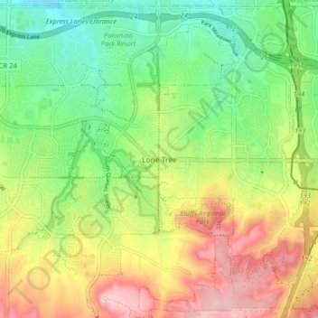
Name: Topografische Karte Lone Tree, Höhe, Relief.
Ort: Lone Tree, Douglas County, Colorado, 80124, United States (39.50710 -104.90935 39.56648 -104.82991)
Durchschnittliche Höhe: 1.818 m
Minimale Höhe: 1.730 m
Maximale Höhe: 1.938 m
Spenden
Rüste dich für dein nächstes Abenteuer:
Als Amazon-Partner verdient diese Website an qualifizierten Käufen, ohne zusätzliche Kosten für Sie.
Andere topografische Karten
Klicken Sie auf eine Karte, um ihre Topografie, ihre Höhe und ihr Relief anzuzeigen.
Spenden
Rüste dich für dein nächstes Abenteuer:
Als Amazon-Partner verdient diese Website an qualifizierten Käufen, ohne zusätzliche Kosten für Sie.
Spenden
Rüste dich für dein nächstes Abenteuer:
Als Amazon-Partner verdient diese Website an qualifizierten Käufen, ohne zusätzliche Kosten für Sie.
Spenden
Rüste dich für dein nächstes Abenteuer:
Als Amazon-Partner verdient diese Website an qualifizierten Käufen, ohne zusätzliche Kosten für Sie.
Spenden
Rüste dich für dein nächstes Abenteuer:
Als Amazon-Partner verdient diese Website an qualifizierten Käufen, ohne zusätzliche Kosten für Sie.
Hidden Mesa Open Space
United States > Colorado > Douglas County > Castle Rock
Durchschnittliche Höhe: 1.902 m
Cherry Creek Highlands
United States > Colorado > Douglas County > Parker
Durchschnittliche Höhe: 1.813 m
Spenden
Rüste dich für dein nächstes Abenteuer:
Als Amazon-Partner verdient diese Website an qualifizierten Käufen, ohne zusätzliche Kosten für Sie.