
Spenden
Rüste dich für dein nächstes Abenteuer:
Als Amazon-Partner verdient diese Website an qualifizierten Käufen, ohne zusätzliche Kosten für Sie.
Topografische Karte Barryville
Klicken Sie auf die Karte, um die Höhe anzuzeigen.
Spenden
Rüste dich für dein nächstes Abenteuer:
Als Amazon-Partner verdient diese Website an qualifizierten Käufen, ohne zusätzliche Kosten für Sie.
Über diese Karte
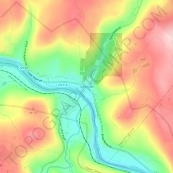
Name: Topografische Karte Barryville, Höhe, Relief.
Durchschnittliche Höhe: 283 m
Minimale Höhe: 154 m
Maximale Höhe: 403 m
Spenden
Rüste dich für dein nächstes Abenteuer:
Als Amazon-Partner verdient diese Website an qualifizierten Käufen, ohne zusätzliche Kosten für Sie.
Andere topografische Karten
Klicken Sie auf eine Karte, um ihre Topografie, ihre Höhe und ihr Relief anzuzeigen.
Mongaup Valley
United States > New York > Sullivan County > Town of Bethel
Durchschnittliche Höhe: 380 m
Spenden
Rüste dich für dein nächstes Abenteuer:
Als Amazon-Partner verdient diese Website an qualifizierten Käufen, ohne zusätzliche Kosten für Sie.
Livingston Manor
United States > New York > Sullivan County > Livingston Manor
Durchschnittliche Höhe: 515 m
Tusten Mountain Lake
United States > New York > Sullivan County > Town of Tusten
Durchschnittliche Höhe: 346 m
Village of Wurtsboro
United States > New York > Sullivan County
Wurtsboro is in the Eastern Time Zone. Its elevation is 577 feet.
Durchschnittliche Höhe: 204 m
Spenden
Rüste dich für dein nächstes Abenteuer:
Als Amazon-Partner verdient diese Website an qualifizierten Käufen, ohne zusätzliche Kosten für Sie.
Spenden
Rüste dich für dein nächstes Abenteuer:
Als Amazon-Partner verdient diese Website an qualifizierten Käufen, ohne zusätzliche Kosten für Sie.
Mountain Dale
United States > New York > Sullivan County > Town of Fallsburg
Mountaindale is a hamlet (and census-designated place) in the town of Fallsburg in Sullivan County, New York, United States, situated at an altitude of 1,010 feet (310 m).
Durchschnittliche Höhe: 363 m
South Fallsburg
United States > New York > Sullivan County > South Fallsburg
Durchschnittliche Höhe: 405 m
Spenden
Rüste dich für dein nächstes Abenteuer:
Als Amazon-Partner verdient diese Website an qualifizierten Käufen, ohne zusätzliche Kosten für Sie.
Spenden
Rüste dich für dein nächstes Abenteuer:
Als Amazon-Partner verdient diese Website an qualifizierten Käufen, ohne zusätzliche Kosten für Sie.
Kauneonga Lake
United States > New York > Sullivan County > Town of Bethel
Durchschnittliche Höhe: 407 m
Livingston Manor
United States > New York > Sullivan County > Livingston Manor
Durchschnittliche Höhe: 512 m
Spenden
Rüste dich für dein nächstes Abenteuer:
Als Amazon-Partner verdient diese Website an qualifizierten Käufen, ohne zusätzliche Kosten für Sie.
Spenden
Rüste dich für dein nächstes Abenteuer:
Als Amazon-Partner verdient diese Website an qualifizierten Käufen, ohne zusätzliche Kosten für Sie.
Grahamsville
United States > New York > Sullivan County > Town of Neversink
Grahamsville is located at latitude 41.848 and longitude -74.548. The elevation is 968 feet. Grahamsville is in the Eastern Time Zone.
Durchschnittliche Höhe: 397 m
Livingston Manor
United States > New York > Sullivan County > Livingston Manor
Durchschnittliche Höhe: 512 m
Spenden
Rüste dich für dein nächstes Abenteuer:
Als Amazon-Partner verdient diese Website an qualifizierten Käufen, ohne zusätzliche Kosten für Sie.
Woodbourne
United States > New York > Sullivan County > Town of Fallsburg > Woodbourne
Durchschnittliche Höhe: 394 m
Mongaup Valley
United States > New York > Sullivan County > Town of Bethel
Durchschnittliche Höhe: 380 m
Spenden
Rüste dich für dein nächstes Abenteuer:
Als Amazon-Partner verdient diese Website an qualifizierten Käufen, ohne zusätzliche Kosten für Sie.
Grahamsville
United States > New York > Sullivan County > Town of Neversink
Grahamsville is located at latitude 41.848 and longitude -74.548. The elevation is 968 feet. Grahamsville is in the Eastern Time Zone.
Durchschnittliche Höhe: 397 m
Spenden
Rüste dich für dein nächstes Abenteuer:
Als Amazon-Partner verdient diese Website an qualifizierten Käufen, ohne zusätzliche Kosten für Sie.
Town of Lumberland
United States > New York > Sullivan County
Lumberland is located within the Upper Delaware Scenic and Recreational River. Elevations range from approximately 600 feet near the Delaware River to over 1,300 feet above sea level on the bluffs overlooking the Delaware, and where the Catskill Mountains begin to rise in the northern reaches of the town. The…
Durchschnittliche Höhe: 360 m
Spenden
Rüste dich für dein nächstes Abenteuer:
Als Amazon-Partner verdient diese Website an qualifizierten Käufen, ohne zusätzliche Kosten für Sie.