
Topografische Karte Iron Horse
Interaktive Karte
Klicken Sie auf die Karte, um die Höhe anzuzeigen.
Über diese Karte
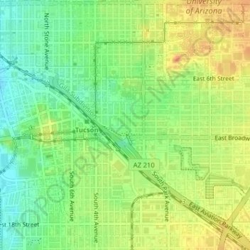
Name: Topografische Karte Iron Horse, Höhe, Relief.
Ort: Iron Horse, Tucson, Pima County, Arizona, United States (32.22037 -110.96606 32.22516 -110.95945)
Durchschnittliche Höhe: 736 m
Minimale Höhe: 716 m
Maximale Höhe: 754 m
Andere topografische Karten
Klicken Sie auf eine Karte, um ihre Topografie, ihre Höhe und ihr Relief anzuzeigen.
Tucson
United States > Arizona > Pima County > Tucson
Tucson, Pima County, Arizona, 85701, United States
Durchschnittliche Höhe: 836 m
Agua Caliente Wash
United States > Arizona > Pima County > Tucson
Agua Caliente Wash, Powder Horn Ranch, Tucson, Pima County, Arizona, United States
Durchschnittliche Höhe: 791 m
Drexel Heights
United States > Arizona > Pima County > Tucson
Drexel Heights, Tucson, Pima County, Arizona, United States
Durchschnittliche Höhe: 786 m
Catalina Foothills
United States > Arizona > Pima County > Tucson
Catalina Foothills, Tucson, Pima County, Arizona, United States
Durchschnittliche Höhe: 949 m
Mitchell Park
United States > Arizona > Pima County > Tucson
Mitchell Park, Mountain 1st Avenue, Tucson, Pima County, Arizona, United States
Durchschnittliche Höhe: 731 m
Archer Lake
United States > Arizona > Pima County > Tucson
Archer Lake, Tucson, Pima County, Arizona, United States
Durchschnittliche Höhe: 695 m
Rillito River
United States > Arizona > Pima County > Tucson
Rillito River, Tucson, Pima County, Arizona, United States
Durchschnittliche Höhe: 790 m