
Spenden
Rüste dich für dein nächstes Abenteuer:
Als Amazon-Partner verdient diese Website an qualifizierten Käufen, ohne zusätzliche Kosten für Sie.
Topografische Karte Bell Island
Klicken Sie auf die Karte, um die Höhe anzuzeigen.
Spenden
Rüste dich für dein nächstes Abenteuer:
Als Amazon-Partner verdient diese Website an qualifizierten Käufen, ohne zusätzliche Kosten für Sie.
Bell Island
The coast is very rocky and consists almost entirely of steep cliffs tens of meters high that tower up to 45 kilometres (28 mi) above sea level. The island, which continues to gain in altitude especially close to the coastline, reaches a maximum height of 148 metres (486 ft). Because the central part of the island is relatively flat compared to the coast, seen from the sea it has a somewhat table mountain-like view. Since the island is so high above sea level, on a clear day there are excellent views of the Newfoundland mainland from either side. The cliffs are home to several sea caves and natural bridges and in several places overlook large rocks and sea stacks. Known are The Bell, Coadys Island and The Clapper, all on the southwest coast. There is also a ravine on the east coast that is known as The Scrape. The Front and Lance Cove are almost the only places where the coast is less steep and where you can land from the sea. To the north are Redmans Head and Eastern Head, two prominent capes between which a lighthouse has been built.
Spenden
Rüste dich für dein nächstes Abenteuer:
Als Amazon-Partner verdient diese Website an qualifizierten Käufen, ohne zusätzliche Kosten für Sie.
Über diese Karte
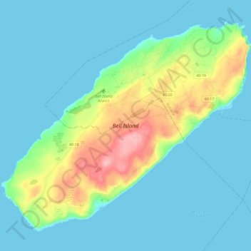
Name: Topografische Karte Bell Island, Höhe, Relief.
Durchschnittliche Höhe: 30 m
Minimale Höhe: -1 m
Maximale Höhe: 141 m
Spenden
Rüste dich für dein nächstes Abenteuer:
Als Amazon-Partner verdient diese Website an qualifizierten Käufen, ohne zusätzliche Kosten für Sie.