
Topografische Karte Chambersburg
Interaktive Karte
Klicken Sie auf die Karte, um die Höhe anzuzeigen.
Über diese Karte
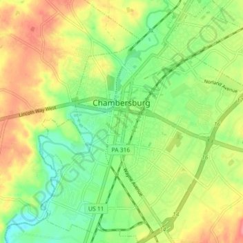
Name: Topografische Karte Chambersburg, Höhe, Relief.
Ort: Chambersburg, Franklin County, Pennsylvania, United States (39.90580 -77.68568 39.96065 -77.62369)
Durchschnittliche Höhe: 200 m
Minimale Höhe: 166 m
Maximale Höhe: 241 m
Chambersburg is served by the Lincoln Highway, U.S. 30, between McConnellsburg and Gettysburg. U.S. 11, the Molly Pitcher Highway, passes through it between Shippensburg, Pennsylvania, and Hagerstown, Maryland. Interstate 81 skirts the borough to its east. The town lies approximately midpoint on US Route 30 between Pittsburgh and Philadelphia. The local topography reflects both flatter areas like Philadelphia and mountainous areas like Pittsburgh. Downtown Chambersburg has occasional events such as Food Truck Festival and Apple Fest.
Andere topografische Karten
Klicken Sie auf eine Karte, um ihre Topografie, ihre Höhe und ihr Relief anzuzeigen.
Waynesboro
United States > Pennsylvania > Franklin County
Waynesboro, Franklin County, Pennsylvania, United States
Durchschnittliche Höhe: 210 m