
Topografische Karte Reno
Interaktive Karte
Klicken Sie auf die Karte, um die Höhe anzuzeigen.
Über diese Karte
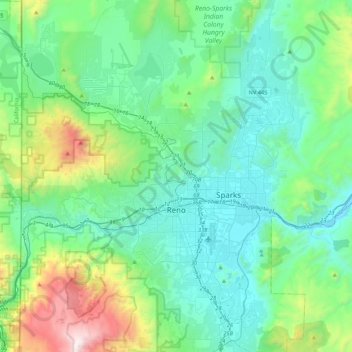
Name: Topografische Karte Reno, Höhe, Relief.
Ort: Reno, Washoe County, Nevada, United States (39.39243 -120.00233 39.72344 -119.69935)
Durchschnittliche Höhe: 1.650 m
Minimale Höhe: 1.316 m
Maximale Höhe: 3.010 m
Reno is just east of the Sierra Nevada, on the western edge of the Great Basin at an elevation of about 4,400 feet (1,300 m) above sea level. Numerous faults exist throughout the region. Most of these are normal (vertical motion) faults associated with the uplift of the various mountain ranges, including the Sierra Nevada.
Andere topografische Karten
Klicken Sie auf eine Karte, um ihre Topografie, ihre Höhe und ihr Relief anzuzeigen.
Cold Springs
United States > Nevada > Washoe County
Cold Springs, Washoe County, Nevada, 89508, United States
Durchschnittliche Höhe: 1.573 m
Nixon
United States > Nevada > Washoe County
Nixon, Washoe County, Nevada, 89424, United States
Durchschnittliche Höhe: 1.209 m
Incline Village-Crystal Bay
United States > Nevada > Washoe County
Incline Village-Crystal Bay, Washoe County, Nevada, United States
Durchschnittliche Höhe: 2.173 m
Sparks
United States > Nevada > Washoe County
Sparks, Washoe County, Nevada, United States
Durchschnittliche Höhe: 1.438 m
Oxbow Nature Study Area
United States > Nevada > Washoe County > Reno > West Reno
Oxbow Nature Study Area, West Reno, Reno, Washoe County, Nevada, United States
Durchschnittliche Höhe: 1.415 m
North Valley
United States > Nevada > Washoe County > Reno
North Valley, Reno, Washoe County, Nevada, 89512, United States
Durchschnittliche Höhe: 1.419 m
Pyramid Lake
United States > Nevada > Washoe County
Pyramid Lake, Washoe County, Nevada, United States
Durchschnittliche Höhe: 1.406 m
New Washoe City
United States > Nevada > Washoe County
New Washoe City, Washoe Valley CCD, Washoe County, Nevada, United States
Durchschnittliche Höhe: 1.589 m