Geolokalisieren

Topografische Karte O Picato

Interaktive Karte

Klicken Sie auf die Karte, um die Höhe anzuzeigen.

Über diese Karte

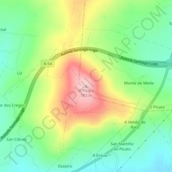
Name: Topografische Karte O Picato, Höhe, Relief.

Ort: O Picato, Lugo, Galicia, 27210, España (42.93486 -7.64830 42.93496 -7.64820)

Durchschnittliche Höhe: 650 m

Minimale Höhe: 566 m

Maximale Höhe: 780 m

Andere topografische Karten

Klicken Sie auf eine Karte, um ihre Topografie, ihre Höhe und ihr Relief anzuzeigen.

Coeses

España > Galicia > Lugo > Lugo

Coeses, Lugo, Galicia, 27181, España

Durchschnittliche Höhe: 447 m

Carballido

España > Galicia > Lugo > Lugo

Carballido, Lugo, Galicia, España

Durchschnittliche Höhe: 506 m

Meilán

España > Galicia > Lugo > Lugo

Meilán, Lugo, Galicia, España

Durchschnittliche Höhe: 456 m

Teixeiro

España > Galicia > Lugo > Lugo

Teixeiro, Lugo, Galicia, España

Durchschnittliche Höhe: 526 m

Segade

España > Galicia > Lugo > Lugo > Segade

Segade, Teixeiro, Lugo, Galicia, 27289, España

Durchschnittliche Höhe: 575 m

A Mera

España > Galicia > Lugo > Lugo

A Mera, O Veral, Lugo, Galicia, 27231, España

Durchschnittliche Höhe: 483 m