
Topografische Karte Athol
Interaktive Karte
Klicken Sie auf die Karte, um die Höhe anzuzeigen.
Über diese Karte
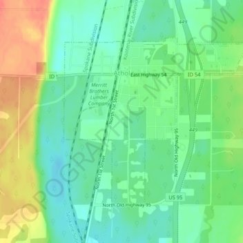
Name: Topografische Karte Athol, Höhe, Relief.
Ort: Athol, Kootenai County, Idaho, United States (47.93325 -116.71762 47.95185 -116.68763)
Durchschnittliche Höhe: 733 m
Minimale Höhe: 714 m
Maximale Höhe: 764 m
Athol is located at 47°56′46″N 116°42′26″W / 47.94611°N 116.70722°W / 47.94611; -116.70722 (47.946024, -116.707349), at an elevation of 2,392 feet (729 m) above sea level.
Andere topografische Karten
Klicken Sie auf eine Karte, um ihre Topografie, ihre Höhe und ihr Relief anzuzeigen.
Coeur d'Alene
United States > Idaho > Kootenai County
Coeur d'Alene, Kootenai County, Idaho, United States
Durchschnittliche Höhe: 719 m
Bayview
United States > Idaho > Kootenai County
Bayview, Kootenai County, Idaho, United States
Durchschnittliche Höhe: 733 m
Post Falls
United States > Idaho > Kootenai County
Post Falls, Kootenai County, Idaho, 83854, United States
Durchschnittliche Höhe: 710 m
Hayden
United States > Idaho > Kootenai County
Hayden, Kootenai County, Idaho, 83835, United States
Durchschnittliche Höhe: 717 m
Rathdrum
United States > Idaho > Kootenai County
Rathdrum, Kootenai County, Idaho, 83858, United States
Durchschnittliche Höhe: 701 m