
Topografische Karte North Little Rock
Interaktive Karte
Klicken Sie auf die Karte, um die Höhe anzuzeigen.
Über diese Karte
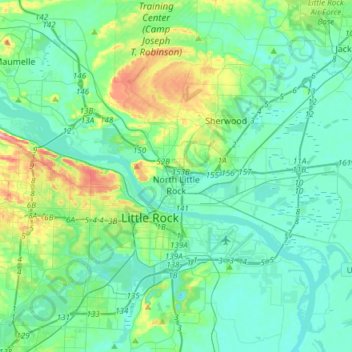
Name: Topografische Karte North Little Rock, Höhe, Relief.
Ort: North Little Rock, Pulaski County, Arkansas, United States (34.67453 -92.40028 34.87742 -92.09819)
Durchschnittliche Höhe: 96 m
Minimale Höhe: 63 m
Maximale Höhe: 232 m
Andere topografische Karten
Klicken Sie auf eine Karte, um ihre Topografie, ihre Höhe und ihr Relief anzuzeigen.
Coulter Lake
United States > Arkansas > Pulaski County > Little Rock
Coulter Lake, Little Rock, Pulaski County, Arkansas, United States
Durchschnittliche Höhe: 100 m
Sherwood
United States > Arkansas > Pulaski County
Sherwood, Pulaski County, Arkansas, 72120, United States
Durchschnittliche Höhe: 108 m
Rose City
United States > Arkansas > Pulaski County > North Little Rock
Rose City, North Little Rock, Pulaski County, Arkansas, 72117, United States
Durchschnittliche Höhe: 76 m
Maumelle
United States > Arkansas > Pulaski County
Maumelle, Pulaski County, Arkansas, 72113, United States
Durchschnittliche Höhe: 87 m
Willow Beach Lake Dam
United States > Arkansas > Pulaski County > North Little Rock
Willow Beach Lake Dam, North Little Rock, Pulaski County, Arkansas, 72142, United States
Durchschnittliche Höhe: 73 m
Maumelle
United States > Arkansas > Pulaski County > Maumelle > Maumelle
Maumelle, Pulaski County, Arkansas, 72113, United States
Durchschnittliche Höhe: 88 m
Little Rock
United States > Arkansas > Pulaski County
Little Rock, Pulaski County, Arkansas, United States
Durchschnittliche Höhe: 96 m
Little Rock
United States > Arkansas > Pulaski County > Little Rock
Little Rock, Pulaski County, Arkansas, 72201, United States
Durchschnittliche Höhe: 98 m