
Topografische Karte Lakewood
Interaktive Karte
Klicken Sie auf die Karte, um die Höhe anzuzeigen.
Über diese Karte
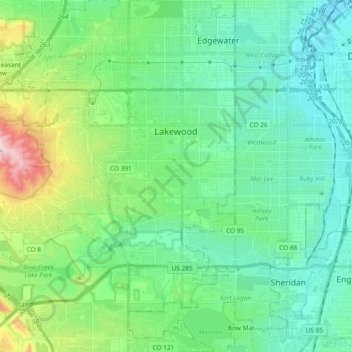
Name: Topografische Karte Lakewood, Höhe, Relief.
Ort: Lakewood, Jefferson County, Colorado, United States (39.61844 -105.20044 39.76196 -105.05321)
Durchschnittliche Höhe: 1.690 m
Minimale Höhe: 1.574 m
Maximale Höhe: 2.087 m
Lakewood is located at 39°42′17″N 105°04′53″W / 39.70472°N 105.08139°W / 39.70472; -105.08139 at an elevation of 5,518 feet (1,682 m). Located at the junction of U.S. Route 6 and Colorado State Highway 121 in central Colorado, the city lies immediately west of Denver and 62 miles (100 km) north-northwest of Colorado Springs.
Andere topografische Karten
Klicken Sie auf eine Karte, um ihre Topografie, ihre Höhe und ihr Relief anzuzeigen.
Golden
United States > Colorado > Jefferson County
Golden, Jefferson County, Colorado, United States
Durchschnittliche Höhe: 1.936 m
Genesee
United States > Colorado > Jefferson County > Golden
Genesee, Golden, Jefferson County, Colorado, 80453, United States
Durchschnittliche Höhe: 2.249 m
Long Scraggy Peak
United States > Colorado > Jefferson County
Long Scraggy Peak, Jefferson County, Colorado, United States
Durchschnittliche Höhe: 2.238 m
Morrison
United States > Colorado > Jefferson County
Morrison, Jefferson County, Colorado, 80465, United States
Durchschnittliche Höhe: 1.892 m
Arvada
United States > Colorado > Jefferson County
Arvada, Jefferson County, Colorado, United States
Durchschnittliche Höhe: 1.665 m
Golden
United States > Colorado > Jefferson County > Golden
Golden, Jefferson County, Colorado, United States
Durchschnittliche Höhe: 1.916 m