
Topografische Karte Knockchree
Interaktive Karte
Klicken Sie auf die Karte, um die Höhe anzuzeigen.
Über diese Karte
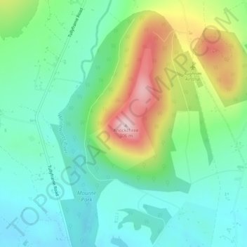
Name: Topografische Karte Knockchree, Höhe, Relief.
Durchschnittliche Höhe: 116 m
Minimale Höhe: 33 m
Maximale Höhe: 302 m
Andere topografische Karten
Klicken Sie auf eine Karte, um ihre Topografie, ihre Höhe und ihr Relief anzuzeigen.
Slieve Donard
United Kingdom > Northern Ireland > County Down
Slieve Donard, County Down, Northern Ireland, BT33 0HD, United Kingdom
Durchschnittliche Höhe: 505 m
Mourne Mountains Middle
United Kingdom > Northern Ireland > County Down
Mourne Mountains Middle, County Down, Northern Ireland, United Kingdom
Durchschnittliche Höhe: 348 m
Banbridge
United Kingdom > Northern Ireland > County Down
Banbridge, County Down, Northern Ireland, BT32 3DB, United Kingdom
Durchschnittliche Höhe: 90 m
Newry
United Kingdom > Northern Ireland > County Down
Newry, County Down, Northern Ireland, United Kingdom
Durchschnittliche Höhe: 73 m
Dromore
United Kingdom > Northern Ireland > County Down
Dromore, County Down, Ulster, Northern Ireland, BT25 1BD, United Kingdom
Durchschnittliche Höhe: 106 m
Drumaness
United Kingdom > Northern Ireland > County Down > Drumaness
Drumaness, County Down, Northern Ireland, BT24 8RL, United Kingdom
Durchschnittliche Höhe: 74 m
Donaghadee
United Kingdom > Northern Ireland > County Down > Donaghadee
Donaghadee, County Down, Northern Ireland, BT21 0BD, United Kingdom
Durchschnittliche Höhe: 10 m
Greencastle
United Kingdom > Northern Ireland > County Down > Greencastle
Greencastle, Greencastle Pier Road, Greencastle, County Down, Northern Ireland, BT34 4LR, United Kingdom
Durchschnittliche Höhe: 1 m
Killyleagh
United Kingdom > Northern Ireland > County Down > Killyleagh
Killyleagh, County Down, Northern Ireland, BT30 9QF, United Kingdom
Durchschnittliche Höhe: 11 m
Clonallan
United Kingdom > Northern Ireland > County Down > Mayobridge
Clonallan, Mayobridge, County Down, Northern Ireland, United Kingdom
Durchschnittliche Höhe: 135 m
Ballymagart
United Kingdom > Northern Ireland > County Down
Ballymagart, County Down, Northern Ireland, United Kingdom
Durchschnittliche Höhe: 33 m
Rathfriland
United Kingdom > Northern Ireland > County Down
Rathfriland, County Down, Northern Ireland, BT34 5NH, United Kingdom
Durchschnittliche Höhe: 97 m
Ardglass
United Kingdom > Northern Ireland > County Down > Ardglass
Ardglass, County Down, Northern Ireland, BT30 7TU, United Kingdom
Durchschnittliche Höhe: 7 m
Ballyquinton Point nature reserve
United Kingdom > Northern Ireland > County Down
Ballyquinton Point nature reserve, County Down, Northern Ireland, United Kingdom
Durchschnittliche Höhe: 2 m
Dundrum
United Kingdom > Northern Ireland > County Down > Dundrum
Dundrum, County Down, Northern Ireland, BT33 0LU, United Kingdom
Durchschnittliche Höhe: 18 m
Kilkeel
United Kingdom > Northern Ireland > County Down > Kilkeel
Kilkeel, County Down, Northern Ireland, BT34 4AF, United Kingdom
Durchschnittliche Höhe: 35 m
Ballyhalbert
United Kingdom > Northern Ireland > County Down > Ballyhalbert
Ballyhalbert, County Down, Northern Ireland, BT22 1DQ, United Kingdom
Durchschnittliche Höhe: 8 m
Drumbo
United Kingdom > Northern Ireland > County Down > Drumbo
Drumbo, County Down, Northern Ireland, BT27 5TX, United Kingdom
Durchschnittliche Höhe: 94 m
Mahee Island
United Kingdom > Northern Ireland > County Down
Mahee Island, County Down, Northern Ireland, United Kingdom
Durchschnittliche Höhe: 2 m
Maghera
United Kingdom > Northern Ireland > County Down
Maghera, County Down, Northern Ireland, BT31 9HE, United Kingdom
Durchschnittliche Höhe: 30 m
Newcastle
United Kingdom > Northern Ireland > County Down > Newcastle
Newcastle, County Down, Northern Ireland, BT33 0AE, United Kingdom
Durchschnittliche Höhe: 115 m
Edenderry
United Kingdom > Northern Ireland > County Down
Edenderry, County Down, Ulster, Northern Ireland, BT8 8LQ, United Kingdom
Durchschnittliche Höhe: 39 m