
Topografische Karte Huston
Interaktive Karte
Klicken Sie auf die Karte, um die Höhe anzuzeigen.
Über diese Karte
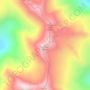
Name: Topografische Karte Huston, Höhe, Relief.
Ort: Huston, Missoula County, Montana, United States (47.55326 -113.58997 47.55336 -113.58987)
Durchschnittliche Höhe: 2.321 m
Minimale Höhe: 1.765 m
Maximale Höhe: 2.723 m
Andere topografische Karten
Klicken Sie auf eine Karte, um ihre Topografie, ihre Höhe und ihr Relief anzuzeigen.
Bancroft Pond Nature Area
United States > Montana > Missoula County > Missoula
Bancroft Pond Nature Area, Lewis & Clark, Missoula, Missoula County, Montana, United States
Durchschnittliche Höhe: 1.005 m
Missoula
United States > Montana > Missoula County
Missoula, Missoula County, Montana, United States
Durchschnittliche Höhe: 1.173 m