
Topografische Karte Abadeh
Interaktive Karte
Klicken Sie auf die Karte, um die Höhe anzuzeigen.
Über diese Karte
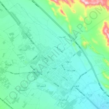
Name: Topografische Karte Abadeh, Höhe, Relief.
Durchschnittliche Höhe: 2.043 m
Minimale Höhe: 1.964 m
Maximale Höhe: 2.374 m
Abadeh (Persian: آباده, also Romanized as Ābādeh) is a city and capital of Abadeh County, in Fars Province, Iran. Abadeh is situated at an elevation of 6,200 feet (1,890 m) in a fertile plain on the high road between Isfahan and Shiraz, 190 kilometres (120 mi) from the former and 270 kilometres (170 mi) from the latter. At the 2006 census, its population was 52,042, in 14,184 families. As of 2009, the population was estimated to be 59,042.