
Spenden
Rüste dich für dein nächstes Abenteuer:
Als Amazon-Partner verdient diese Website an qualifizierten Käufen, ohne zusätzliche Kosten für Sie.
Topografische Karte Davao de Oro
Klicken Sie auf die Karte, um die Höhe anzuzeigen.
Spenden
Rüste dich für dein nächstes Abenteuer:
Als Amazon-Partner verdient diese Website an qualifizierten Käufen, ohne zusätzliche Kosten für Sie.
Über diese Karte
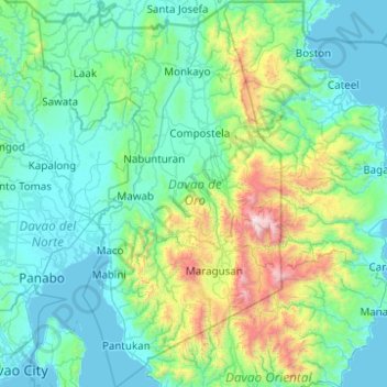
Name: Topografische Karte Davao de Oro, Höhe, Relief.
Ort: Davao de Oro, Davao Region, Philippines (7.01949 125.65597 8.00245 126.29580)
Durchschnittliche Höhe: 361 m
Minimale Höhe: 0 m
Maximale Höhe: 2.628 m
Spenden
Rüste dich für dein nächstes Abenteuer:
Als Amazon-Partner verdient diese Website an qualifizierten Käufen, ohne zusätzliche Kosten für Sie.
Andere topografische Karten
Klicken Sie auf eine Karte, um ihre Topografie, ihre Höhe und ihr Relief anzuzeigen.
Tagaytay
The southern and eastern portions of Tagaytay are covered by hills and mountains which is generally forests, pine trees and open grasslands. The city lies along Tagaytay Ridge, a ridge stretching about 32 kilometres (20 mi) from Mount Batulao in the west to Mount Sungay in the east with elevations averaging…
Durchschnittliche Höhe: 229 m
Spenden
Rüste dich für dein nächstes Abenteuer:
Als Amazon-Partner verdient diese Website an qualifizierten Käufen, ohne zusätzliche Kosten für Sie.
Quezon City
Founded as a pueblo by Saint Pedro Bautista in 1590, San Francisco del Monte may be considered Quezon City's oldest district. The original land area of the old town of San Francisco del Monte was approximately2.5 square kilometres (1.0 sq mi) and covered parts of what is currently known as Project 7 and 8 and…
Durchschnittliche Höhe: 57 m
Baguio
In 1903, Filipinos, Japanese and Chinese workers were hired to build Kennon Road, the first road directly connecting Baguio with the lowlands of La Union and Pangasinan. Before this, the only road to Benguet was Naguilian Road, and it was largely a horse trail at higher elevations. Camp John Hay was…
Durchschnittliche Höhe: 881 m
Legazpi
Legazpi's topography is generally plain on the northeastern areas, with slopes ranging from five to fifteen degrees. The southern areas have mostly rolling to hilly terrain. In the city's coastal areas, the terrain varies from plain (north) to hilly (south). Legazpi is criss-crossed by several rivers including…
Durchschnittliche Höhe: 150 m
Spenden
Rüste dich für dein nächstes Abenteuer:
Als Amazon-Partner verdient diese Website an qualifizierten Käufen, ohne zusätzliche Kosten für Sie.
Spenden
Rüste dich für dein nächstes Abenteuer:
Als Amazon-Partner verdient diese Website an qualifizierten Käufen, ohne zusätzliche Kosten für Sie.
Spenden
Rüste dich für dein nächstes Abenteuer:
Als Amazon-Partner verdient diese Website an qualifizierten Käufen, ohne zusätzliche Kosten für Sie.
Spenden
Rüste dich für dein nächstes Abenteuer:
Als Amazon-Partner verdient diese Website an qualifizierten Käufen, ohne zusätzliche Kosten für Sie.
Mandaluyong
Another claims that the Spaniards named the place based on the report of a navigator named Acapulco, who saw the rolling hills frequently being lashed at by daluyong (“big waves from the sea”). This seems to confirm traditional pre-Hispanic stories that giant waves from the sea would meet the adjoining…
Durchschnittliche Höhe: 33 m
Spenden
Rüste dich für dein nächstes Abenteuer:
Als Amazon-Partner verdient diese Website an qualifizierten Käufen, ohne zusätzliche Kosten für Sie.
Trece Martires
The city of Trece Martires is characterised with ground elevation ranging from 30m to nearly 400m. Its ground slope ranges from 0.5 to 2%.
Durchschnittliche Höhe: 150 m
Spenden
Rüste dich für dein nächstes Abenteuer:
Als Amazon-Partner verdient diese Website an qualifizierten Käufen, ohne zusätzliche Kosten für Sie.
Spenden
Rüste dich für dein nächstes Abenteuer:
Als Amazon-Partner verdient diese Website an qualifizierten Käufen, ohne zusätzliche Kosten für Sie.
Mount Mayon
Philippines > Albay > Tabaco
On February 23, 2023, a twin engine Cessna 340 airplane owned by the Energy Development Corporation departed Bicol International Airport in the early morning on an executive flight to the capital Manila. A few minutes after takeoff, while climbing to an altitude of 6,000 ft (1,800 m), it impacted the rocky…
Durchschnittliche Höhe: 1.696 m
Spenden
Rüste dich für dein nächstes Abenteuer:
Als Amazon-Partner verdient diese Website an qualifizierten Käufen, ohne zusätzliche Kosten für Sie.
Spenden
Rüste dich für dein nächstes Abenteuer:
Als Amazon-Partner verdient diese Website an qualifizierten Käufen, ohne zusätzliche Kosten für Sie.
Spenden
Rüste dich für dein nächstes Abenteuer:
Als Amazon-Partner verdient diese Website an qualifizierten Käufen, ohne zusätzliche Kosten für Sie.
Spenden
Rüste dich für dein nächstes Abenteuer:
Als Amazon-Partner verdient diese Website an qualifizierten Käufen, ohne zusätzliche Kosten für Sie.
Spenden
Rüste dich für dein nächstes Abenteuer:
Als Amazon-Partner verdient diese Website an qualifizierten Käufen, ohne zusätzliche Kosten für Sie.
Spenden
Rüste dich für dein nächstes Abenteuer:
Als Amazon-Partner verdient diese Website an qualifizierten Käufen, ohne zusätzliche Kosten für Sie.
Spenden
Rüste dich für dein nächstes Abenteuer:
Als Amazon-Partner verdient diese Website an qualifizierten Käufen, ohne zusätzliche Kosten für Sie.
San Juan
"San Juan" is a contraction of the city's traditional name of "San Juan del Monte" (lit. 'Saint John of the Mountain'). As with numerous other places in the Philippines, the name combines a patron saint and a toponym; in this case Saint John the Baptist with the locale's hilly terrain and relatively higher…
Durchschnittliche Höhe: 35 m
Spenden
Rüste dich für dein nächstes Abenteuer:
Als Amazon-Partner verdient diese Website an qualifizierten Käufen, ohne zusätzliche Kosten für Sie.
Spenden
Rüste dich für dein nächstes Abenteuer:
Als Amazon-Partner verdient diese Website an qualifizierten Käufen, ohne zusätzliche Kosten für Sie.
Spenden
Rüste dich für dein nächstes Abenteuer:
Als Amazon-Partner verdient diese Website an qualifizierten Käufen, ohne zusätzliche Kosten für Sie.
Spenden
Rüste dich für dein nächstes Abenteuer:
Als Amazon-Partner verdient diese Website an qualifizierten Käufen, ohne zusätzliche Kosten für Sie.
Spenden
Rüste dich für dein nächstes Abenteuer:
Als Amazon-Partner verdient diese Website an qualifizierten Käufen, ohne zusätzliche Kosten für Sie.
Spenden
Rüste dich für dein nächstes Abenteuer:
Als Amazon-Partner verdient diese Website an qualifizierten Käufen, ohne zusätzliche Kosten für Sie.
Spenden
Rüste dich für dein nächstes Abenteuer:
Als Amazon-Partner verdient diese Website an qualifizierten Käufen, ohne zusätzliche Kosten für Sie.
Spenden
Rüste dich für dein nächstes Abenteuer:
Als Amazon-Partner verdient diese Website an qualifizierten Käufen, ohne zusätzliche Kosten für Sie.
Spenden
Rüste dich für dein nächstes Abenteuer:
Als Amazon-Partner verdient diese Website an qualifizierten Käufen, ohne zusätzliche Kosten für Sie.
Spenden
Rüste dich für dein nächstes Abenteuer:
Als Amazon-Partner verdient diese Website an qualifizierten Käufen, ohne zusätzliche Kosten für Sie.