
Topografische Karte Tour de communication de La Hoube
Interaktive Karte
Klicken Sie auf die Karte, um die Höhe anzuzeigen.
Über diese Karte
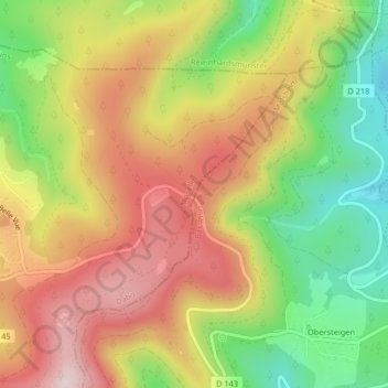
Name: Topografische Karte Tour de communication de La Hoube, Höhe, Relief.
Durchschnittliche Höhe: 554 m
Minimale Höhe: 359 m
Maximale Höhe: 737 m
Andere topografische Karten
Klicken Sie auf eine Karte, um ihre Topografie, ihre Höhe und ihr Relief anzuzeigen.
Borne Saint-Martin
France > Grand Est > Moselle > Dabo
Borne Saint-Martin, Dabo, Sarrebourg-Château-Salins, Moselle, Grand Est, France métropolitaine, 57850, France
Durchschnittliche Höhe: 446 m
Rothenbuhl
France > Grand Est > Moselle > Dabo
Rothenbuhl, Dabo, Sarrebourg-Château-Salins, Moselle, Grand Est, France métropolitaine, 57850, France
Durchschnittliche Höhe: 475 m