
Topografische Karte Hawick
Klicken Sie auf die Karte, um die Höhe anzuzeigen.
Über diese Karte
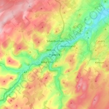
Name: Topografische Karte Hawick, Höhe, Relief.
Ort: Hawick, Scottish Borders, Scotland, TD9 9EG, United Kingdom (55.38256 -2.82670 55.46256 -2.74670)
Durchschnittliche Höhe: 199 m
Minimale Höhe: 79 m
Maximale Höhe: 322 m
Andere topografische Karten
Klicken Sie auf eine Karte, um ihre Topografie, ihre Höhe und ihr Relief anzuzeigen.
Greenknowe Tower
United Kingdom > Scotland > Scottish Borders > Gordon > Nether Huntlywood
Durchschnittliche Höhe: 157 m
Moffat Hills
United Kingdom > Scotland > Scottish Borders > Tweedsmuir
The Megget Stane (OS. Ref. NT152203) is by a cattle grid at the highest point between the Talla and Megget reservoirs on the minor road which runs from Tweedsmuir on the A701 to Cappercleuch by shore of St Mary's Loch. It is quite easy to miss the stone when coming from Talla as it is hidden by a gate. At an…
Durchschnittliche Höhe: 430 m
Curling Pond
United Kingdom > Scotland > Scottish Borders > Earlston > Georgefield
Durchschnittliche Höhe: 153 m
Hirsel Lake
United Kingdom > Scotland > Scottish Borders > Coldstream > The Hirsel
Durchschnittliche Höhe: 37 m