
Spenden
Rüste dich für dein nächstes Abenteuer:
Als Amazon-Partner verdient diese Website an qualifizierten Käufen, ohne zusätzliche Kosten für Sie.
Topografische Karte Mount Arayat
Klicken Sie auf die Karte, um die Höhe anzuzeigen.
Spenden
Rüste dich für dein nächstes Abenteuer:
Als Amazon-Partner verdient diese Website an qualifizierten Käufen, ohne zusätzliche Kosten für Sie.
Mount Arayat
Mount Arayat stands in the middle of the flat Central Luzon Plain, consisting of rice paddies and a typical elevation of about 15 to 35 metres MSL. The mountain is topped by a circular volcanic crater about 1.2 kilometres (0.75 mi) in diameter, much of which has collapsed on the western and part of the northern rim due to erosion. This has resulted in a breached crater which opens in a west-northwest direction. This area is the apparent source of a major debris-avalanche deposit that forms hummocky terrain beyond the west and northwest sides of the volcano. The 1,026-metre (3,366 ft) summit stands on the northeast side of the breached crater, known as North Peak, while the 984-metre (3,228 ft) Pinnacle Peak is located on the southeast crater rim. Post-collapse activity formed an andesitic lava dome known as White Rock in the collapse amphitheater.
Spenden
Rüste dich für dein nächstes Abenteuer:
Als Amazon-Partner verdient diese Website an qualifizierten Käufen, ohne zusätzliche Kosten für Sie.
Über diese Karte
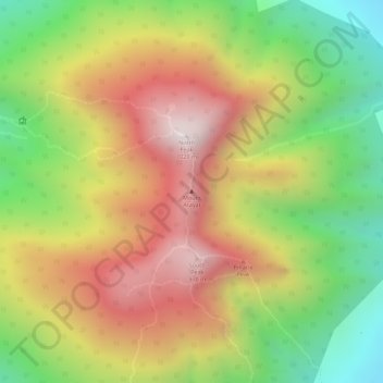
Name: Topografische Karte Mount Arayat, Höhe, Relief.
Durchschnittliche Höhe: 639 m
Minimale Höhe: 246 m
Maximale Höhe: 995 m
Spenden
Rüste dich für dein nächstes Abenteuer:
Als Amazon-Partner verdient diese Website an qualifizierten Käufen, ohne zusätzliche Kosten für Sie.
Andere topografische Karten
Klicken Sie auf eine Karte, um ihre Topografie, ihre Höhe und ihr Relief anzuzeigen.