
Topografische Karte York
Interaktive Karte
Klicken Sie auf die Karte, um die Höhe anzuzeigen.
Über diese Karte
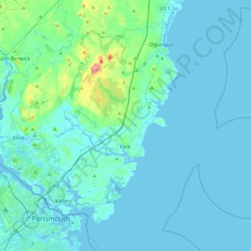
Name: Topografische Karte York, Höhe, Relief.
Ort: York, York County, Maine, United States (43.07006 -70.75739 43.26087 -70.40476)
Durchschnittliche Höhe: 18 m
Minimale Höhe: -6 m
Maximale Höhe: 206 m
According to the United States Census Bureau, the town has a total area of 131.78 square miles (341.31 km2), of which 54.67 square miles (141.59 km2) is land and 77.11 square miles (199.71 km2) is water. The York watershed drains into the York River. The highest point in town is Mount Agamenticus, with an elevation of 692 feet (211 meters) above sea level. A road travels to the summit, where miles of hiking, biking and horse-riding trails are available. The lowest point in town is sea level, along the coastline with the Atlantic Ocean. York lies about 44 miles (71 km) south of Portland, 98 miles (158 km) south of Augusta, and 65 miles (105 km) north of Boston.
Andere topografische Karten
Klicken Sie auf eine Karte, um ihre Topografie, ihre Höhe und ihr Relief anzuzeigen.
temp
United States > Maine > York County > Hollis
temp, Hollis, York County, Maine, 04042, United States
Durchschnittliche Höhe: 103 m
Kittery
United States > Maine > York County
Kittery, York County, Maine, United States
Durchschnittliche Höhe: 8 m
Newfield
United States > Maine > York County
Newfield, York County, Maine, 04095, United States
Durchschnittliche Höhe: 155 m
Mill Brook
United States > Maine > York County > Old Orchard Beach
Mill Brook, Old Orchard Beach, York County, Maine, 04064, United States
Durchschnittliche Höhe: 21 m
Biddeford
United States > Maine > York County
Biddeford, York County, Maine, 04005, United States
Durchschnittliche Höhe: 21 m