
Topografische Karte Camp Hill
Interaktive Karte
Klicken Sie auf die Karte, um die Höhe anzuzeigen.
Über diese Karte
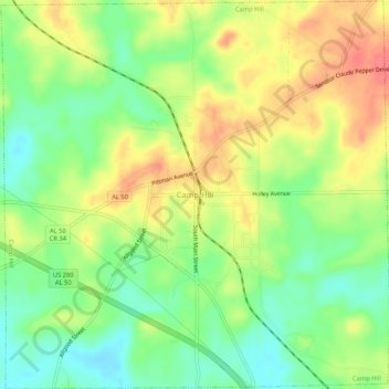
Name: Topografische Karte Camp Hill, Höhe, Relief.
Ort: Camp Hill, Tallapoosa County, Alabama, 36850, United States (32.77828 -85.67987 32.82244 -85.62723)
Durchschnittliche Höhe: 203 m
Minimale Höhe: 172 m
Maximale Höhe: 237 m
Andere topografische Karten
Klicken Sie auf eine Karte, um ihre Topografie, ihre Höhe und ihr Relief anzuzeigen.
Hawaii Island
United States > Alabama > Tallapoosa County
Hawaii Island, Tallapoosa County, Alabama, United States
Durchschnittliche Höhe: 149 m
Lake Martin
United States > Alabama > Tallapoosa County > Alexander City
Lake Martin, Alexander City, Tallapoosa County, Alabama, 36861, United States
Durchschnittliche Höhe: 175 m
Carrville
United States > Alabama > Tallapoosa County > Tallassee
Carrville, Tallassee, Tallapoosa County, Alabama, 36078, United States
Durchschnittliche Höhe: 112 m
Dadeville
United States > Alabama > Tallapoosa County
Dadeville, Tallapoosa County, Alabama, United States
Durchschnittliche Höhe: 195 m
Alexander City
United States > Alabama > Tallapoosa County
Alexander City, Tallapoosa County, Alabama, 35010, United States
Durchschnittliche Höhe: 188 m