
Topografische Karte Farnham
Interaktive Karte
Klicken Sie auf die Karte, um die Höhe anzuzeigen.
Über diese Karte
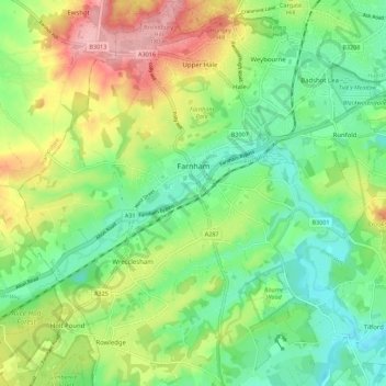
Name: Topografische Karte Farnham, Höhe, Relief.
Ort: Farnham, Waverley, Surrey, England, United Kingdom (51.17548 -0.84893 51.24507 -0.74160)
Durchschnittliche Höhe: 100 m
Minimale Höhe: 46 m
Maximale Höhe: 190 m
Farnham lies in the valley of the North Branch of the River Wey, which rises near Alton, merges with the South Branch at Tilford, and joins the River Thames at Weybridge. The mainly east–west alignment of the ridges and valleys has influenced the development of road and rail communications. The most prominent geological feature is the chalk of the North Downs which forms a ridge (the Hog's Back) to the east of the town, and continues through Farnham Park to the north of the town centre, and westwards to form the Hampshire Downs. The land rises to more than 180 metres (590 feet) above sea level (ASL) to the north of the town at Caesar's Camp which, with the northern part of the park, lies on gravel beds. There are a number of swallow holes in the park where this stratum meets the chalk. The historic core of the town lies on gravel beds at an altitude of roughly 70 metres (230 ft) ASL on an underlying geology of Gault Clay and Upper Greensand and the southern part of the town rises to more than 100 metres (330 feet) on the Lower Greensand.