
Topografische Karte Municipal Unit of Nafpaktos
Interaktive Karte
Klicken Sie auf die Karte, um die Höhe anzuzeigen.
Über diese Karte
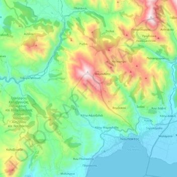
Name: Topografische Karte Municipal Unit of Nafpaktos, Höhe, Relief.
Durchschnittliche Höhe: 421 m
Minimale Höhe: -6 m
Maximale Höhe: 1.465 m
Andere topografische Karten
Klicken Sie auf eine Karte, um ihre Topografie, ihre Höhe und ihr Relief anzuzeigen.
Nafpaktos
Greece > Peloponnese, Western Greece and the Ionian > Municipal Unit of Nafpaktos > Nafpaktos
Nafpaktos, Municipal Unit of Nafpaktos, Municipality of Nafpaktia, Aetolia-Acarnania Regional Unit, Western Greece, Peloponnese, Western Greece and the Ionian, 30300, Greece
Durchschnittliche Höhe: 130 m