
Topografische Karte Flat Rock
Interaktive Karte
Klicken Sie auf die Karte, um die Höhe anzuzeigen.
Über diese Karte
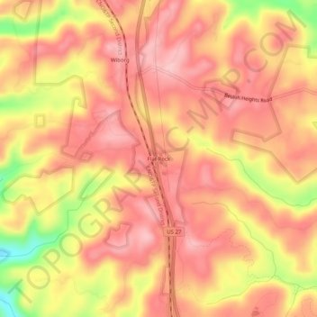
Name: Topografische Karte Flat Rock, Höhe, Relief.
Ort: Flat Rock, McCreary County, Kentucky, 42653, United States (36.77675 -84.50466 36.81675 -84.46466)
Durchschnittliche Höhe: 374 m
Minimale Höhe: 263 m
Maximale Höhe: 424 m
Andere topografische Karten
Klicken Sie auf eine Karte, um ihre Topografie, ihre Höhe und ihr Relief anzuzeigen.
Cumberland Falls
United States > Kentucky > McCreary County
Cumberland Falls, McCreary County, Kentucky, 42634, United States
Durchschnittliche Höhe: 312 m
Stearns
United States > Kentucky > McCreary County
Stearns, McCreary County, Kentucky, United States
Durchschnittliche Höhe: 392 m
Yamacraw
United States > Kentucky > McCreary County
Yamacraw, McCreary County, Kentucky, 42647, United States
Durchschnittliche Höhe: 315 m
Bell Farm
United States > Kentucky > McCreary County
Bell Farm, McCreary County, Kentucky, United States
Durchschnittliche Höhe: 369 m
Strunk
United States > Kentucky > McCreary County > Strunk
Strunk, McCreary County, Kentucky, 42649, United States
Durchschnittliche Höhe: 410 m
Pine Knot
United States > Kentucky > McCreary County
Pine Knot, McCreary County, Kentucky, United States
Durchschnittliche Höhe: 399 m
Whitley City
United States > Kentucky > McCreary County
Whitley City, McCreary County, Kentucky, 42563, United States
Durchschnittliche Höhe: 390 m