
Topografische Karte Navarre
Interaktive Karte
Klicken Sie auf die Karte, um die Höhe anzuzeigen.
Über diese Karte
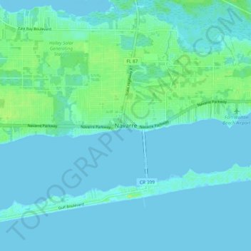
Name: Topografische Karte Navarre, Höhe, Relief.
Ort: Navarre, Santa Rosa County, Florida, 32566, United States (30.36198 -86.91008 30.44198 -86.83008)
Durchschnittliche Höhe: 4 m
Minimale Höhe: -4 m
Maximale Höhe: 25 m
Navarre is located at 30°24′04″N 86°51′47″W / 30.401°N 86.863°W / 30.401; -86.863Coordinates: 30°24′04″N 86°51′47″W / 30.401°N 86.863°W / 30.401; -86.863. It is located within a portion of the Florida Panhandle observing the Central Time Zone. Elevation is at an average of 10 feet (3.0 m).
Andere topografische Karten
Klicken Sie auf eine Karte, um ihre Topografie, ihre Höhe und ihr Relief anzuzeigen.
East Milton
United States > Florida > Santa Rosa County
East Milton, Santa Rosa County, Florida, 32572, United States
Durchschnittliche Höhe: 8 m
Pace
United States > Florida > Santa Rosa County
Pace, Santa Rosa County, Florida, United States
Durchschnittliche Höhe: 17 m
Milton
United States > Florida > Santa Rosa County
Milton, Santa Rosa County, Florida, 32572, United States
Durchschnittliche Höhe: 15 m