
Topografische Karte Diamond
Interaktive Karte
Klicken Sie auf die Karte, um die Höhe anzuzeigen.
Über diese Karte
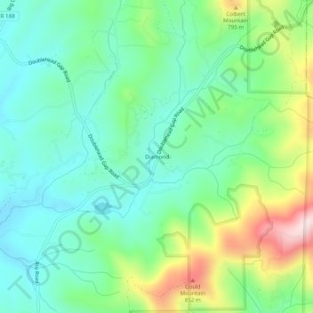
Name: Topografische Karte Diamond, Höhe, Relief.
Ort: Diamond, Gilmer County, Georgia, United States (34.65425 -84.29603 34.69425 -84.25603)
Durchschnittliche Höhe: 644 m
Minimale Höhe: 526 m
Maximale Höhe: 926 m
Andere topografische Karten
Klicken Sie auf eine Karte, um ihre Topografie, ihre Höhe und ihr Relief anzuzeigen.
Ellijay
United States > Georgia > Gilmer County
Ellijay, Gilmer County, Georgia, 30540, United States
Durchschnittliche Höhe: 424 m
East Ellijay
United States > Georgia > Gilmer County
East Ellijay, Gilmer County, Georgia, United States
Durchschnittliche Höhe: 440 m
Cherry Log
United States > Georgia > Gilmer County
Cherry Log, Gilmer County, Georgia, United States
Durchschnittliche Höhe: 522 m
Chopped Oak
United States > Georgia > Gilmer County
Chopped Oak, Gilmer County, Georgia, United States
Durchschnittliche Höhe: 560 m
Carters Lake
United States > Georgia > Gilmer County
Carters Lake, Gilmer County, Georgia, United States
Durchschnittliche Höhe: 370 m
Burnett
United States > Georgia > Gilmer County
Burnett, Gilmer County, Georgia, United States
Durchschnittliche Höhe: 578 m