
Topografische Karte Leslie
Interaktive Karte
Klicken Sie auf die Karte, um die Höhe anzuzeigen.
Über diese Karte
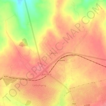
Name: Topografische Karte Leslie, Höhe, Relief.
Durchschnittliche Höhe: 1.664 m
Minimale Höhe: 1.612 m
Maximale Höhe: 1.684 m
Andere topografische Karten
Klicken Sie auf eine Karte, um ihre Topografie, ihre Höhe und ihr Relief anzuzeigen.
Evander
South Africa > Mpumalanga > Gert Sibande > Govan Mbeki Local Municipality
Evander, Govan Mbeki Local Municipality, Gert Sibande, Mpumalanga, 2280, South Africa
Durchschnittliche Höhe: 1.628 m
Bethal
South Africa > Mpumalanga > Gert Sibande > Govan Mbeki Local Municipality
Bethal, Govan Mbeki Local Municipality, Gert Sibande, Mpumalanga, South Africa
Durchschnittliche Höhe: 1.662 m