Geolokalisieren

Topografische Karte Paddock Lake

Interaktive Karte

Klicken Sie auf die Karte, um die Höhe anzuzeigen.

Über diese Karte

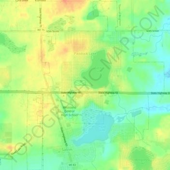
Name: Topografische Karte Paddock Lake, Höhe, Relief.

Ort: Paddock Lake, Kenosha County, Wisconsin, 53168, United States (42.54985 -88.12396 42.59013 -88.07963)

Durchschnittliche Höhe: 244 m

Minimale Höhe: 223 m

Maximale Höhe: 267 m

Andere topografische Karten

Klicken Sie auf eine Karte, um ihre Topografie, ihre Höhe und ihr Relief anzuzeigen.

Town of Wheatland

United States > Wisconsin > Kenosha County

Town of Wheatland, Kenosha County, Wisconsin, 53152, United States

Durchschnittliche Höhe: 244 m

Town of Randall

United States > Wisconsin > Kenosha County

Town of Randall, Kenosha County, Wisconsin, United States

Durchschnittliche Höhe: 259 m

Village of Somers

United States > Wisconsin > Kenosha County

Village of Somers, Kenosha County, Wisconsin, United States

Durchschnittliche Höhe: 206 m

Kenosha

United States > Wisconsin > Kenosha County

Kenosha, Kenosha County, Wisconsin, United States

Durchschnittliche Höhe: 190 m

Pleasant Prairie

United States > Wisconsin > Kenosha County

Pleasant Prairie, Kenosha County, Wisconsin, 53158, United States

Durchschnittliche Höhe: 199 m

Salem Lakes

United States > Wisconsin > Kenosha County

Salem Lakes, Kenosha County, Wisconsin, United States

Durchschnittliche Höhe: 241 m

Bristol

United States > Wisconsin > Kenosha County

Bristol, Kenosha County, Wisconsin, 53104, United States

Durchschnittliche Höhe: 226 m