
Topografische Karte Saint-Gaultier
Interaktive Karte
Klicken Sie auf die Karte, um die Höhe anzuzeigen.
Über diese Karte
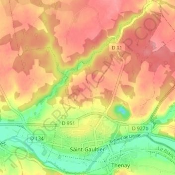
Name: Topografische Karte Saint-Gaultier, Höhe, Relief.
Durchschnittliche Höhe: 134 m
Minimale Höhe: 80 m
Maximale Höhe: 170 m
Andere topografische Karten
Klicken Sie auf eine Karte, um ihre Topografie, ihre Höhe und ihr Relief anzuzeigen.
Lys-Saint-Georges
France > Centre-Val de Loire > Indre
Lys-Saint-Georges, La Châtre, Indre, Centre-Val de Loire, France métropolitaine, 36230, France
Durchschnittliche Höhe: 188 m
Châteauroux
France > Centre-Val de Loire > Indre > Châteauroux
Châteauroux, Indre, Centre-Val de Loire, France métropolitaine, 36000, France
Durchschnittliche Höhe: 153 m
Hurtebise
France > Centre-Val de Loire > Indre > Villegongis
Hurtebise, Villegongis, Châteauroux, Indre, Centre-Val de Loire, France métropolitaine, 36110, France
Durchschnittliche Höhe: 156 m
Murs
France > Centre-Val de Loire > Indre
Murs, Châteauroux, Indre, Centre-Val de Loire, France métropolitaine, 36700, France
Durchschnittliche Höhe: 131 m