
Topografische Karte North East
Interaktive Karte
Klicken Sie auf die Karte, um die Höhe anzuzeigen.
Über diese Karte
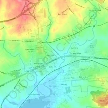
Name: Topografische Karte North East, Höhe, Relief.
Ort: North East, Cecil County, Maryland, 21901, United States (39.59006 -75.96022 39.63610 -75.91396)
Durchschnittliche Höhe: 38 m
Minimale Höhe: -1 m
Maximale Höhe: 106 m
Andere topografische Karten
Klicken Sie auf eine Karte, um ihre Topografie, ihre Höhe und ihr Relief anzuzeigen.
Charlestown
United States > Maryland > Cecil County
Charlestown, Cecil County, Maryland, 21914, United States
Durchschnittliche Höhe: 9 m
Courthouse Point Managed Hunting Area
United States > Maryland > Cecil County > Harbor View
Courthouse Point Managed Hunting Area, Harbor View, Cecil County, Maryland, United States
Durchschnittliche Höhe: 13 m
Elkton
United States > Maryland > Cecil County > Elkton
Elkton, Cecil County, Maryland, United States
Durchschnittliche Höhe: 20 m
Perryville
United States > Maryland > Cecil County > Perryville
Perryville, Cecil County, Maryland, United States
Durchschnittliche Höhe: 46 m