
Topografische Karte Taza National Park
Interaktive Karte
Klicken Sie auf die Karte, um die Höhe anzuzeigen.
Über diese Karte
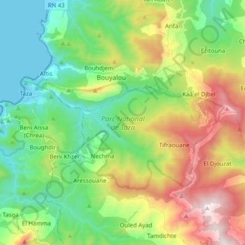
Name: Topografische Karte Taza National Park, Höhe, Relief.
Durchschnittliche Höhe: 437 m
Minimale Höhe: 0 m
Maximale Höhe: 1.273 m
At lower altitudes, the Guerrouch forest is largely dominated by cork oaks, but higher up Algerian chestnut-leaved oak (Quercus afares) and Algerian oak (Quercus canariensis) are also present and there is a plentiful understorey of bird cherry (Prunus avium), Mediterranean willow (Salix pedicellata), European alder (Alnus glutinosa), Montpellier maple (Acer monspessulanum) and narrow-leaved ash (Fraxinus angustifolia).
Andere topografische Karten
Klicken Sie auf eine Karte, um ihre Topografie, ihre Höhe und ihr Relief anzuzeigen.
Selma Ben Ziada
Algeria > Jijel > El Aouana District > Selma Ben Ziada
Selma Ben Ziada, El Aouana District, Jijel, Algeria
Durchschnittliche Höhe: 709 m