
Topografische Karte Sixteen Mile Creek
Interaktive Karte
Klicken Sie auf die Karte, um die Höhe anzuzeigen.
Über diese Karte
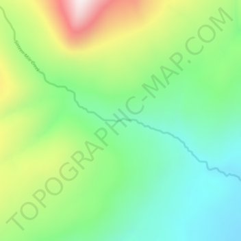
Name: Topografische Karte Sixteen Mile Creek, Höhe, Relief.
Durchschnittliche Höhe: 1.267 m
Minimale Höhe: 1.027 m
Maximale Höhe: 1.711 m
Andere topografische Karten
Klicken Sie auf eine Karte, um ihre Topografie, ihre Höhe und ihr Relief anzuzeigen.
Beaver Lake
Canada > British Columbia > Regional District of Kitimat-Stikine > Area F (Dease Lake) > Dease Lake
Beaver Lake, Dease Lake, Area F (Dease Lake), Regional District of Kitimat-Stikine, British Columbia, Canada
Durchschnittliche Höhe: 865 m
Dease Lake
Canada > British Columbia > Regional District of Kitimat-Stikine > Area F (Dease Lake)
Dease Lake, Area F (Dease Lake), Regional District of Kitimat-Stikine, British Columbia, V0C 1L0, Canada
Durchschnittliche Höhe: 898 m
Ball Creek
Canada > British Columbia > Regional District of Kitimat-Stikine > Area F (Dease Lake)
Ball Creek, Area F (Dease Lake), Regional District of Kitimat-Stikine, British Columbia, Canada
Durchschnittliche Höhe: 1.267 m