
Topografische Karte Saint Cloud
Interaktive Karte
Klicken Sie auf die Karte, um die Höhe anzuzeigen.
Über diese Karte
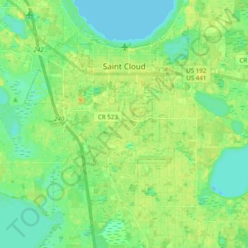
Name: Topografische Karte Saint Cloud, Höhe, Relief.
Ort: Saint Cloud, Osceola County, Florida, United States (28.17356 -81.33948 28.26930 -81.20169)
Durchschnittliche Höhe: 21 m
Minimale Höhe: 12 m
Maximale Höhe: 32 m
Andere topografische Karten
Klicken Sie auf eine Karte, um ihre Topografie, ihre Höhe und ihr Relief anzuzeigen.
Four Corners
United States > Florida > Osceola County > Four Corners
Four Corners, Osceola County, Florida, United States
Durchschnittliche Höhe: 34 m
Kissimmee
United States > Florida > Osceola County
Kissimmee, Osceola County, Florida, United States
Durchschnittliche Höhe: 23 m
Poinciana
United States > Florida > Osceola County > Poinciana
Poinciana, Osceola County, Florida, United States
Durchschnittliche Höhe: 24 m
Pine Grove
United States > Florida > Osceola County > Pine Grove
Pine Grove, Osceola County, Florida, 34771, United States
Durchschnittliche Höhe: 20 m
Reedy Creek
United States > Florida > Osceola County > Poinciana
Reedy Creek, Poinciana, Reedy Creek Improvement District, Osceola County, Florida, 34747, United States
Durchschnittliche Höhe: 27 m