
Topografische Karte Napier
Interaktive Karte
Klicken Sie auf die Karte, um die Höhe anzuzeigen.
Über diese Karte
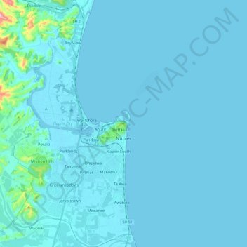
Name: Topografische Karte Napier, Höhe, Relief.
Ort: Napier, Hawke's Bay, New Zealand (-39.57047 176.81127 -39.38819 176.92593)
Durchschnittliche Höhe: 12 m
Minimale Höhe: -3 m
Maximale Höhe: 276 m
The city is on Napier Hill and the surrounding Heretaunga Plains at the southeastern edge of Hawke Bay, a large semi-circular bay that dominates the east coast of New Zealand's North Island. The coastline of the city was substantially altered by a large earthquake in 1931. The topography puts Napier in danger from a tsunami, as the centre of the commercial city is near sea level – should the sea ever crest Marine Parade the sea would run through to Ahuriri. Furthermore, by virtue of its pre 1931 existence, the bulk of Napier is susceptible to soil liquefaction, the risk classed as Very High for the main urban area excluding the hill.
Andere topografische Karten
Klicken Sie auf eine Karte, um ihre Topografie, ihre Höhe und ihr Relief anzuzeigen.
Taumatawhakatangihangakōauauotamateapōkaiwhenuakitānatahu
New Zealand > Hawke's Bay > Central Hawke's Bay District
Taumatawhakatangihangakōauauotamateapōkaiwhenuakitānatahu, Central Hawke's Bay District, Hawke's Bay, New Zealand
Durchschnittliche Höhe: 199 m
Cape Kidnappers / Te Kauwae-a-Māui
New Zealand > Hawke's Bay > Hastings District
Cape Kidnappers / Te Kauwae-a-Māui, Hastings District, Hawke's Bay, New Zealand
Durchschnittliche Höhe: 16 m
Ohingaora
New Zealand > Hawke's Bay > Napier
Ohingaora, Napier, Hawke's Bay, 4141, New Zealand
Durchschnittliche Höhe: 23 m
Folgers Hill
New Zealand > Hawke's Bay > Central Hawke's Bay District
Folgers Hill, Central Hawke's Bay District, Hawke's Bay, New Zealand
Durchschnittliche Höhe: 519 m
Hastings
New Zealand > Hawke's Bay > Hastings District
Hastings, Hastings District, Hawke's Bay, 4122, New Zealand
Durchschnittliche Höhe: 68 m