
Topografische Karte High Park
Interaktive Karte
Klicken Sie auf die Karte, um die Höhe anzuzeigen.
Über diese Karte
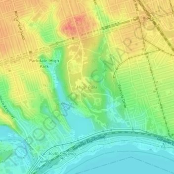
Name: Topografische Karte High Park, Höhe, Relief.
Durchschnittliche Höhe: 97 m
Minimale Höhe: 70 m
Maximale Höhe: 129 m
Andere topografische Karten
Klicken Sie auf eine Karte, um ihre Topografie, ihre Höhe und ihr Relief anzuzeigen.
Toronto
Despite its deep ravines, Toronto is not remarkably hilly, but its elevation does increase steadily away from the lake. Elevation differences range from 76.5 metres (251 ft) above sea level at the Lake Ontario shore to 209 m (686 ft) ASL near the York University grounds in the city's north end at the…
Durchschnittliche Höhe: 113 m
Scarborough
Topographically, Scarborough is dominated by two watersheds, Highland Creek and the Rouge River. Highland Creek lies almost entirely within Scarborough and occupies approximately 70% of its total area. It occupies the western half of Scarborough, while the Rouge River flows through the eastern portion. Both of…
Durchschnittliche Höhe: 138 m
Scarborough
Topographically, the district is dominated by two watersheds, Highland Creek and the Rouge River. Highland Creek lies almost entirely within Scarborough and occupies approximately 70% of its total area. It occupies the western half of Scarborough, while the Rouge River flows through the eastern portion. Both…
Durchschnittliche Höhe: 138 m