
Topografische Karte McCall
Interaktive Karte
Klicken Sie auf die Karte, um die Höhe anzuzeigen.
Über diese Karte
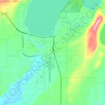
Name: Topografische Karte McCall, Höhe, Relief.
Ort: McCall, Valley County, Idaho, 83638, United States (44.86605 -116.16411 44.93408 -116.06501)
Durchschnittliche Höhe: 1.546 m
Minimale Höhe: 1.491 m
Maximale Höhe: 1.703 m
McCall is located at 44°54′39″N 116°6′11″W / 44.91083°N 116.10306°W / 44.91083; -116.10306 (44.910906, -116.103087),[7] at an elevation of 5,013 feet (1,528 m) above sea level.
Andere topografische Karten
Klicken Sie auf eine Karte, um ihre Topografie, ihre Höhe und ihr Relief anzuzeigen.
Yellow Pine
United States > Idaho > Valley County
Yellow Pine, Valley County, Idaho, 83677, United States
Durchschnittliche Höhe: 1.619 m
Buckhorn Summit
United States > Idaho > Valley County
Buckhorn Summit, Valley County, Idaho, United States
Durchschnittliche Höhe: 2.294 m
Chief
United States > Idaho > Valley County
Chief, Valley County, Idaho, United States
Durchschnittliche Höhe: 2.249 m
Marsh Creek
United States > Idaho > Valley County
Marsh Creek, Valley County, Idaho, United States
Durchschnittliche Höhe: 2.269 m