
Spenden
Rüste dich für dein nächstes Abenteuer:
Als Amazon-Partner verdient diese Website an qualifizierten Käufen, ohne zusätzliche Kosten für Sie.
Topografische Karte Silver Reef
Klicken Sie auf die Karte, um die Höhe anzuzeigen.
Spenden
Rüste dich für dein nächstes Abenteuer:
Als Amazon-Partner verdient diese Website an qualifizierten Käufen, ohne zusätzliche Kosten für Sie.
Silver Reef
Silver Reef is close to the western border of the Colorado Plateau and about 15 miles (24 km) northeast of St. George and 1 mile (1.6 km) west of Leeds. Dixie National Forest, Leeds Creek, the White Reef, and the Pine Valley Mountain Wilderness lie directly west of Silver Reef. The Pine Valley Mountain Wilderness has sage steppe, mountain brush, pinyon pine, coniferous trees, and ponderosa pine. Interstate 15 and Toquerville are 1 mile (1.6 km) and 4 miles (6.4 km) east of Silver Reef, respectively. Pintura is 9.5 miles (15.3 km) north of Silver Reef, and Quail Creek State Park, the ghost town of Harrisburg, the Buckeye Reef, and Red Cliffs Recreation Area are south of Silver Reef. The elevation of Red Cliffs Recreation Area is between 2,000 feet (610 m) and 3,000 feet (910 m).
Spenden
Rüste dich für dein nächstes Abenteuer:
Als Amazon-Partner verdient diese Website an qualifizierten Käufen, ohne zusätzliche Kosten für Sie.
Über diese Karte
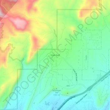
Name: Topografische Karte Silver Reef, Höhe, Relief.
Durchschnittliche Höhe: 1.185 m
Minimale Höhe: 1.042 m
Maximale Höhe: 1.455 m
Spenden
Rüste dich für dein nächstes Abenteuer:
Als Amazon-Partner verdient diese Website an qualifizierten Käufen, ohne zusätzliche Kosten für Sie.