
Topografische Karte Uribia
Interaktive Karte
Klicken Sie auf die Karte, um die Höhe anzuzeigen.
Über diese Karte
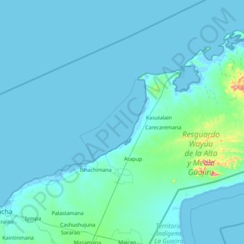
Name: Topografische Karte Uribia, Höhe, Relief.
Ort: Uribia, La Guajira, RAP Caribe, 440029, Colombia (11.52523 -72.38007 12.45733 -71.11296)
Durchschnittliche Höhe: 21 m
Minimale Höhe: -6 m
Maximale Höhe: 623 m
Uribia is a town and municipality of the La Guajira department of Colombia. It is the youngest municipality of this Department since the year 2000. Northern Zone of the Cerrejón coal mines are located in this municipality. The municipality also contains the Serranía de Macuira mountain range which is an isolated low altitude mountain range in the middle of La Guajira Desert. One third of this mountain range is also a National Natural Park of Colombia.
Andere topografische Karten
Klicken Sie auf eine Karte, um ihre Topografie, ihre Höhe und ihr Relief anzuzeigen.
Boca Grande
Colombia > La Guajira > Riohacha > Boca Grande
Boca Grande, Riohacha, La Guajira, 24-58, Colombia
Durchschnittliche Höhe: 10 m
Dibulla
Dibulla, La Guajira, RAP Caribe, 446009, Colombia
Durchschnittliche Höhe: 1.044 m
Barrancas
Barrancas, La Guajira, RAP Caribe, Colombia
Durchschnittliche Höhe: 451 m
Riohacha
Colombia > La Guajira > Riohacha
Riohacha, La Guajira, 44001, Colombia
Durchschnittliche Höhe: 9 m