
Topografische Karte Lilliwaup
Interaktive Karte
Klicken Sie auf die Karte, um die Höhe anzuzeigen.
Über diese Karte
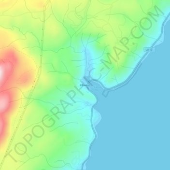
Name: Topografische Karte Lilliwaup, Höhe, Relief.
Ort: Lilliwaup, Mason County, Washington, United States (47.44258 -123.13590 47.48258 -123.09590)
Durchschnittliche Höhe: 114 m
Minimale Höhe: -2 m
Maximale Höhe: 411 m
Andere topografische Karten
Klicken Sie auf eine Karte, um ihre Topografie, ihre Höhe und ihr Relief anzuzeigen.
Hood Canal
United States > Washington > Mason County > Hoodsport
Hood Canal, Port Ludlow, Hoodsport, Mason County, Washington, United States
Durchschnittliche Höhe: 287 m
Shelton
United States > Washington > Mason County > Shelton > Shelton
Shelton, Mason County, Washington, 98555, United States
Durchschnittliche Höhe: 55 m
Shelton
United States > Washington > Mason County
Shelton, Mason County, Washington, United States
Durchschnittliche Höhe: 54 m