
Topografische Karte Clarksville
Interaktive Karte
Klicken Sie auf die Karte, um die Höhe anzuzeigen.
Über diese Karte
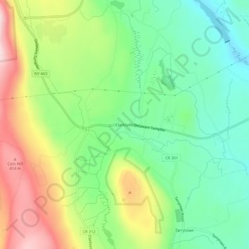
Name: Topografische Karte Clarksville, Höhe, Relief.
Durchschnittliche Höhe: 243 m
Minimale Höhe: 110 m
Maximale Höhe: 456 m
Andere topografische Karten
Klicken Sie auf eine Karte, um ihre Topografie, ihre Höhe und ihr Relief anzuzeigen.
Wolf Hill
United States > New York > Albany County > Town of New Scotland
Wolf Hill, Town of New Scotland, Albany County, New York, 12041, United States
Durchschnittliche Höhe: 385 m
Unionville
United States > New York > Albany County > Town of New Scotland
Unionville, Town of New Scotland, Albany County, New York, 12067, United States
Durchschnittliche Höhe: 88 m
Tarrytown
United States > New York > Albany County > Town of New Scotland
Tarrytown, Town of New Scotland, Albany County, New York, 12041, United States
Durchschnittliche Höhe: 222 m
New Salem
United States > New York > Albany County > Town of New Scotland
New Salem, Town of New Scotland, Albany County, New York, 12186, United States
Durchschnittliche Höhe: 212 m
Feura Bush
United States > New York > Albany County > Town of New Scotland
Feura Bush, Town of New Scotland, Albany County, New York, 12607, United States
Durchschnittliche Höhe: 95 m
John Boyd Thacher State Park
United States > New York > Albany County > Town of New Scotland
John Boyd Thacher State Park, Town of New Scotland, Albany County, New York, United States
Durchschnittliche Höhe: 262 m
Village of Voorheesville
United States > New York > Albany County > Town of New Scotland
Village of Voorheesville, Town of New Scotland, Albany County, New York, 12186, United States
Durchschnittliche Höhe: 107 m