
Topografische Karte Frametown
Interaktive Karte
Klicken Sie auf die Karte, um die Höhe anzuzeigen.
Über diese Karte
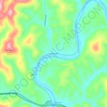
Name: Topografische Karte Frametown, Höhe, Relief.
Durchschnittliche Höhe: 307 m
Minimale Höhe: 233 m
Maximale Höhe: 457 m
Andere topografische Karten
Klicken Sie auf eine Karte, um ihre Topografie, ihre Höhe und ihr Relief anzuzeigen.
Heaters
United States > West Virginia > Braxton County
Heaters, Braxton County, West Virginia, 26627, United States
Durchschnittliche Höhe: 324 m
Rosedale
United States > West Virginia > Braxton County
Rosedale, Braxton County, West Virginia, 26636, United States
Durchschnittliche Höhe: 317 m
Orlando
United States > West Virginia > Braxton County
Orlando, Braxton County, West Virginia, 26412, United States
Durchschnittliche Höhe: 322 m
Burnsville
United States > West Virginia > Braxton County
Burnsville, Braxton County, West Virginia, 26335, United States
Durchschnittliche Höhe: 295 m
Napier
United States > West Virginia > Braxton County
Napier, Braxton County, West Virginia, 26631, United States
Durchschnittliche Höhe: 317 m
Copen
United States > West Virginia > Braxton County
Copen, Braxton County, West Virginia, 26615, United States
Durchschnittliche Höhe: 334 m
Sutton
United States > West Virginia > Braxton County
Sutton, Braxton County, West Virginia, United States
Durchschnittliche Höhe: 320 m
Gassaway
United States > West Virginia > Braxton County
Gassaway, Braxton County, West Virginia, 26624, United States
Durchschnittliche Höhe: 318 m
Burnsville Lake
United States > West Virginia > Braxton County
Burnsville Lake, Braxton County, West Virginia, United States
Durchschnittliche Höhe: 318 m
Flatwoods
United States > West Virginia > Braxton County
Flatwoods, Braxton County, West Virginia, United States
Durchschnittliche Höhe: 364 m
Dutch
United States > West Virginia > Braxton County > Dutch
Dutch, Braxton County, West Virginia, 26627, United States
Durchschnittliche Höhe: 328 m
Little Birch
United States > West Virginia > Braxton County > Little Birch
Little Birch, Braxton County, West Virginia, 26629, United States
Durchschnittliche Höhe: 440 m