
Topografische Karte Grand Prismatic Spring
Interaktive Karte
Klicken Sie auf die Karte, um die Höhe anzuzeigen.
Über diese Karte
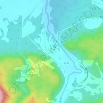
Name: Topografische Karte Grand Prismatic Spring, Höhe, Relief.
Durchschnittliche Höhe: 2.237 m
Minimale Höhe: 2.196 m
Maximale Höhe: 2.400 m
Andere topografische Karten
Klicken Sie auf eine Karte, um ihre Topografie, ihre Höhe und ihr Relief anzuzeigen.
Rocky Mountains
United States > Wyoming > Teton County
Rocky Mountains, Teton County, Wyoming, United States
Durchschnittliche Höhe: 2.292 m
Moose Mountain
United States > Wyoming > Teton County
Moose Mountain, Teton County, Wyoming, United States
Durchschnittliche Höhe: 2.821 m
Yellowstone Caldera Supervolcano
United States > Wyoming > Teton County
Yellowstone Caldera Supervolcano, Teton County, Wyoming, United States
Durchschnittliche Höhe: 2.530 m
West Thumb
United States > Wyoming > Teton County
West Thumb, Teton County, Wyoming, United States
Durchschnittliche Höhe: 2.383 m
Phelps Lake
United States > Wyoming > Teton County
Phelps Lake, Teton County, Wyoming, United States
Durchschnittliche Höhe: 2.084 m
Teton Village
United States > Wyoming > Teton County > Teton Village
Teton Village, Teton County, Wyoming, 83025, United States
Durchschnittliche Höhe: 2.323 m
White Dome Geyser
United States > Wyoming > Teton County
White Dome Geyser, Lower Geyser Basin, Teton County, Wyoming, United States
Durchschnittliche Höhe: 2.255 m
Battleship Mountain
United States > Wyoming > Teton County
Battleship Mountain, Teton County, Wyoming, United States
Durchschnittliche Höhe: 2.924 m
Heart Lake
United States > Wyoming > Teton County
Heart Lake, Teton County, Wyoming, United States
Durchschnittliche Höhe: 2.301 m
Porcupine Hills
United States > Wyoming > Teton County
Porcupine Hills, Teton County, Wyoming, United States
Durchschnittliche Höhe: 2.223 m
Grand Teton National Park
United States > Wyoming > Teton County
Grand Teton National Park, Teton County, Wyoming, United States
Durchschnittliche Höhe: 2.409 m