
Topografische Karte Kyustendil
Interaktive Karte
Klicken Sie auf die Karte, um die Höhe anzuzeigen.
Über diese Karte
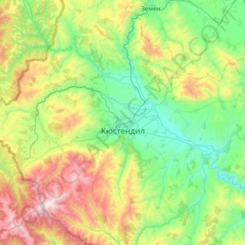
Name: Topografische Karte Kyustendil, Höhe, Relief.
Ort: Kyustendil, Bulgaria (42.09792 22.35980 42.48571 22.89789)
Durchschnittliche Höhe: 939 m
Minimale Höhe: 402 m
Maximale Höhe: 2.246 m
Kyustendil is a national balneological resort at an altitude of 600 metres. There are more than 40 mineral springs in the town. The waters have a high content of sulfite compounds. These are used for the treatment of the locomotory system, gynecological and other kinds of diseases. The resort region includes several baths, balneological complexes and others.
Andere topografische Karten
Klicken Sie auf eine Karte, um ihre Topografie, ihre Höhe und ihr Relief anzuzeigen.
Panichishte
Panichishte, Sapareva Bania, Kyustendil, 2650, Bulgaria
Durchschnittliche Höhe: 1.326 m
Dupnitsa
Bulgaria > Kyustendil > Dupnitsa
Dupnitsa, Kyustendil, 2604, Bulgaria
Durchschnittliche Höhe: 848 m