
Spenden
Rüste dich für dein nächstes Abenteuer:
Als Amazon-Partner verdient diese Website an qualifizierten Käufen, ohne zusätzliche Kosten für Sie.
Topografische Karte Kandukur
Klicken Sie auf die Karte, um die Höhe anzuzeigen.
Spenden
Rüste dich für dein nächstes Abenteuer:
Als Amazon-Partner verdient diese Website an qualifizierten Käufen, ohne zusätzliche Kosten für Sie.
Kandukur
Kandukuru (earlier known as Skandapuri) is located at 15°12′59″N 79°54′15″E / 15.2165°N 79.9042°E / 15.2165; 79.9042. It has an average elevation of 13 metres (43 ft). Kandukur was a part of the erstwhile Nellore district and was then included in the newly carved out Prakasam District in 1970. Later as a part of the district's reorganization in 2022, it is now merged with the residual SPSR Nellore district. The total geographical area of Kandukur Municipality is 37.63 sq km.
Spenden
Rüste dich für dein nächstes Abenteuer:
Als Amazon-Partner verdient diese Website an qualifizierten Käufen, ohne zusätzliche Kosten für Sie.
Über diese Karte
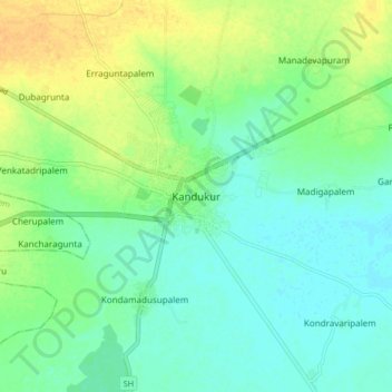
Name: Topografische Karte Kandukur, Höhe, Relief.
Durchschnittliche Höhe: 18 m
Minimale Höhe: 7 m
Maximale Höhe: 36 m
Spenden
Rüste dich für dein nächstes Abenteuer:
Als Amazon-Partner verdient diese Website an qualifizierten Käufen, ohne zusätzliche Kosten für Sie.
Andere topografische Karten
Klicken Sie auf eine Karte, um ihre Topografie, ihre Höhe und ihr Relief anzuzeigen.