
Topografische Karte Arborio
Interaktive Karte
Klicken Sie auf die Karte, um die Höhe anzuzeigen.
Über diese Karte
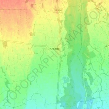
Name: Topografische Karte Arborio, Höhe, Relief.
Ort: Arborio, Vercelli, Piedmont, 13031, Italy (45.46693 8.34052 45.51740 8.41408)
Durchschnittliche Höhe: 184 m
Minimale Höhe: 164 m
Maximale Höhe: 207 m
Andere topografische Karten
Klicken Sie auf eine Karte, um ihre Topografie, ihre Höhe und ihr Relief anzuzeigen.
La Mandria
Italy > Piedmont > Vercelli > Santhià
La Mandria, Santhià, Vercelli, Piedmont, 13048, Italy
Durchschnittliche Höhe: 214 m
Torrente Mastallone
Italy > Piedmont > Vercelli > Fobello
Torrente Mastallone, Fobello, Cellio con Breia, Vercelli, Piedmont, 13055, Italy
Durchschnittliche Höhe: 1.189 m