
Topografische Karte New Lenox
Interaktive Karte
Klicken Sie auf die Karte, um die Höhe anzuzeigen.
Über diese Karte
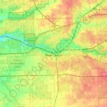
Name: Topografische Karte New Lenox, Höhe, Relief.
Ort: New Lenox, Will County, Illinois, 60451, United States (41.46077 -88.02610 41.56651 -87.90743)
Durchschnittliche Höhe: 209 m
Minimale Höhe: 177 m
Maximale Höhe: 237 m
Andere topografische Karten
Klicken Sie auf eine Karte, um ihre Topografie, ihre Höhe und ihr Relief anzuzeigen.
Welco Corners
United States > Illinois > Will County > Bolingbrook
Welco Corners, Bolingbrook, Will County, Illinois, 60440, United States
Durchschnittliche Höhe: 219 m
Frankfort
United States > Illinois > Will County > Frankfort
Frankfort, Will County, Illinois, United States
Durchschnittliche Höhe: 225 m
Wilmington
United States > Illinois > Will County > Wilmington
Wilmington, Will County, Illinois, 60481, United States
Durchschnittliche Höhe: 175 m
Joliet
United States > Illinois > Will County
Joliet, Will County, Illinois, United States
Durchschnittliche Höhe: 195 m
Plainfield
United States > Illinois > Will County
Plainfield, Will County, Illinois, United States
Durchschnittliche Höhe: 194 m