
Topografische Karte Cashel
Interaktive Karte
Klicken Sie auf die Karte, um die Höhe anzuzeigen.
Über diese Karte
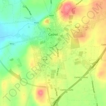
Name: Topografische Karte Cashel, Höhe, Relief.
Durchschnittliche Höhe: 115 m
Minimale Höhe: 77 m
Maximale Höhe: 154 m
The Rock of Cashel, to which the town below owes its origin, is an isolated elevation of stratified limestone, rising abruptly from a broad and fertile plain called the Golden Vale. The top of this eminence is crowned by a group of remarkable ruins. Originally known as Fairy Hill, or Sid-Druim, the Rock was, in pagan times, the dun, or castle, of the ancient Eoghnacht Chiefs of Munster. In Gaelic, Caiseal denotes a circular stone fort and is the name of several places in Ireland. The "Book of Rights" suggests the name is derived from Cais-il, i.e. "tribute stone", because the Munster tribes paid tribute on the Rock. Here Corc, grandfather of Aengus Mac Natfraich, erected a fort. Cashel subsequently became the capital of Munster and, like Tara and Armagh, it was a celebrated court. At the time of St. Patrick, when Aengus ruled as king, Cashel claimed supremacy over all the royal duns of the province.
Andere topografische Karten
Klicken Sie auf eine Karte, um ihre Topografie, ihre Höhe und ihr Relief anzuzeigen.
Ring Hill
Ring Hill, The Municipal District of Thurles, County Tipperary, Munster, Ireland
Durchschnittliche Höhe: 315 m
Cahir
Cahir, The Municipal District of Cahir — Cashel, County Tipperary, Munster, Ireland
Durchschnittliche Höhe: 58 m
The Municipal District of Cahir — Cashel
The Municipal District of Cahir — Cashel, County Tipperary, Munster, Ireland
Durchschnittliche Höhe: 143 m
Southhill
Southhill, Nenagh Rural, The Municipal District of Nenagh, County Tipperary, Munster, Ireland
Durchschnittliche Höhe: 76 m
The Municipal District of Nenagh
The Municipal District of Nenagh, County Tipperary, Munster, Ireland
Durchschnittliche Höhe: 116 m
Lattin
Lattin, The Municipal District of Cahir — Cashel, County Tipperary, Munster, Ireland
Durchschnittliche Höhe: 134 m
Haywood
Haywood, Clonmel Rural, The Borough District of Clonmel, County Tipperary, Munster, Ireland
Durchschnittliche Höhe: 55 m
The Municipal District of Carrick-on-Suir
The Municipal District of Carrick-on-Suir, County Tipperary, Munster, Ireland
Durchschnittliche Höhe: 118 m
The Municipal District of Thurles
The Municipal District of Thurles, County Tipperary, Munster, Ireland
Durchschnittliche Höhe: 144 m
Forest
Forest, Drom, The Municipal District of Thurles, County Tipperary, Munster, Ireland
Durchschnittliche Höhe: 113 m