
Topografische Karte Lac de Gaube
Interaktive Karte
Klicken Sie auf die Karte, um die Höhe anzuzeigen.
Lac de Gaube
The lake is situated in an altitude of 1725 m, an egg-shaped form stretching itself along a north–south axis in the valley of Gaube. This steep-sided valley is located at the foot of the Vignemale (3298M). The lake is surrounded by the peak Mayouret (2688 m) to the east, the big Peak of the Paloumères (2720 m) to the southeast, and the peak of Gaube (2377 m) to the northwest.
Über diese Karte
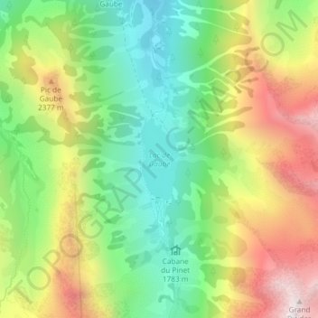
Name: Topografische Karte Lac de Gaube, Höhe, Relief.
Durchschnittliche Höhe: 2.079 m
Minimale Höhe: 1.642 m
Maximale Höhe: 2.689 m
Andere topografische Karten
Klicken Sie auf eine Karte, um ihre Topografie, ihre Höhe und ihr Relief anzuzeigen.
Vue sur Cascades et Pont d'Espagne
France > Occitania > Hautes Pyrenees > Cauterets
Durchschnittliche Höhe: 1.827 m